Rocking the Abrolhos
 Sunday, January 23, 2011 at 5:05AM
 This is the first post from onboard the R/V Seward Johnson, currently at 18 deg 6 min S, 38 deg 25 min W, somewhere off the coast of Bahia State, Brazil.
_______________________
Alex Bastos likes rocks. Biologists may scoff, but the truth is that rocks and geology provide the context for biology in the oceans, much the same way as a playing field provides the context for a game of football. In an expedition concerned with coral reef ecology, then, it’s important to have a thorough understanding of geological processes, because they shape the history of the reef and can help predict its future. Dr. Bastos, who hails from the Federal University of Espirito Santo, is a marine geologist with a special interest in the Abrolhos. He is trying to understand what has happened in the prehistoric past and what is happening on the reef today by reading the shape of the bottom features (what geologists like to call morphology) and reconstructing a story and past and present events on the Abrolhos shelf. Scientists call this sort of activity “inferring process from pattern”, and in terms of marine geology it brings with it some special challenges. The biggest of these is that, for the most part, Alex can’t see the morphology he wants to study, certainly not as easily as a terrestrial geologist might fly above a mountain range and read the faults and synclines of the landscape to understand what geological forces shaped the land. No, he has to construct his story a piece or two at a time, like putting together a jigsaw puzzle, often from indirect evidence. He gets his jigsaw pieces from some pretty cool technology though, including seismic equipment, side scan sonar and by drilling cores out of the sediment.
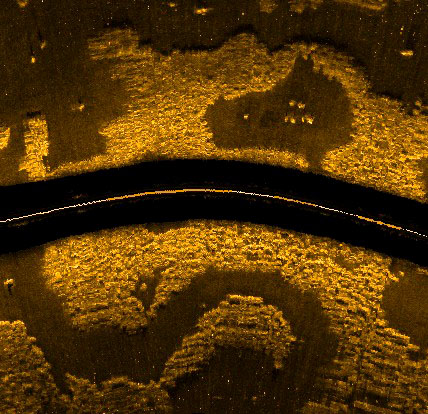
Side scan sonar is an especially great tool that has become really popular in research circles in recent years. It uses sound to reconstruct bottom morphology by sending out high frequency noises and then gathering back the echoes off the bottom, much the same way bats find food. What makes side scan different from regular sonar is that instead of aiming the sound straight down under the boat, it is directed away to each side. Since the sound hits objects and bounces back at an angle, any structure of any height will cast a sort of sound “shadow” on the side facing away from the boat. The resulting image is a plan view, but with shadows that reveal shapes and structures, rather like taking a photo from an aeroplane late in the day, when shadows are long on the ground.
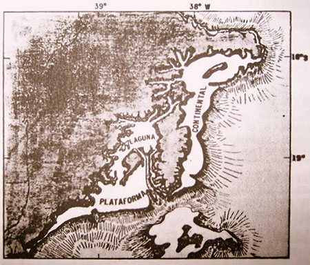
 Side-scan reveals and ancient river channel. Img: Alex BastosBy combining studies of morphology with reconstructions of sea level at different times in geological history, Alex tells a story about the way the Abrolhos platform evolved. Around 40 million years ago the main playing field was established by a flood of volcanic basalt that spread out to create the basis of the platform. In the ensuing geological periods, carbonate rocks (i.e. limestone) were deposited, implying that reefs existed there at times in the distant past (my assertion in a previous post that there were no reefs on Abrolhos before 8,000 years ago was wrong). During the last ice age, the sea level was over 100m lower than its current height, so much of the platform, including the locations of all the current shallow coral reefs, was above the surface. At that time, a central depression in the platform was probably still filled with water, forming a shallow coastal lagoon opening to the south. The Caravelas River probably drained into this lagoon from the north, cutting a number of different channels through the limestone as it meandered over time. The river also provided a source of sediment that fanned out off the edge of the platform from the mouth of the lagoon. All three of these features – the shallow depression, the channels in the limestone and the sediment fan – are still there on the bottom of the sea and help to tell the story. At the end of the last ice age came the last great transgression, when sea level rose to approximately its current levels. The entire platform was flooded, and corals once again colonized the platform and began to grow up towards the surface to where we see them today.
 How Abrolhos might have looked during the last ice age; note the central lagoon opening to the south
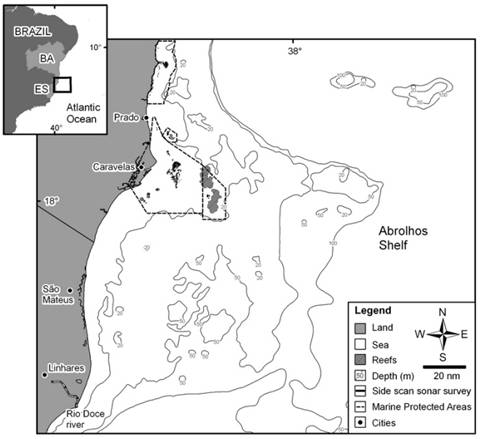
 Current bottom topography of Abrolhos; note central depression due south of the islands
Holocene sedimentary processes.
Unfortunately, morphology only gets you so far. Knowing the history of the platform, many of Dr. Bastos’ questions now relate to what has happened since the last transgression, during the most recent geological period (the Holocene), and most of these need other methods to answer. These questions include “Is all the sediment on the platform a relict of geological history, or are sediments actively being deposited to this day?” and “If they are still being deposited, do they come from the land via the river, or are they produced in the ocean by corals, coralline algae and other organisms?” To answer these questions, Alex will use a combination of seismic methods and sediment cores. Seismic surveys provide indirect evidence of the nature of sediments below the surface of the sea bed, and these can be calibrated or “ground-truthed” by taking sediment cores that will reveal a timeline of sediment history on the platform. These geological questions played a large part in the choice of sites for the main transects on this expedition. One is to the south, in the mouth of that ice-aged lagoon, on the edge of the shallow-sloping fan of sediment. The other is in the north, on a much steeper shelf break where the platform gives way to the deep sea beyond. These two locations not only have profoundly different geology, but it’s likely that organic processes differ between them too, as we shall see in a future post.
Applying the lessons
Alex was telling me that one of the more satisfying aspects of his work is translating geology data into benthic (bottom) habitat maps. In other words, taking all that information from the sonar morphology, the seismic data and the sediment cores, and mapping out what different parts of the platform are like on the bottom. This is important, because once scientists can say with confidence that Area X is a rhodolith bed, or Area Y is a steep-sided valley, then they can predict with good accuracy what sorts of organisms will live there. That sort of information is of critical value when deciding where to take biological samples and even more so when the Ministry of the Environment needs to make decisions about the boundaries of protected areas, which they are currently doing. In this way geology plays a very important role in both the biological sciences and in conservation decision making.


Reader Comments