Networked Blogs
Search this site
Twitter and News feeds
Navigation

Entries in HBOI (18)

Sunday
Feb202011

As promised, more of the Johnson Sea Link

When we were on the Abrolhos research cruise aboard the HBOI/CEPEMAR ship Seward Johnson recently, I posted a little clip of the outside of the sub.  In that post I promised better quality and longer clips when I got back to land.  So here, (in HD goodness if you want it) is long-time pilot Don Liberatore giving a neat history of the Johnson Sea Link 2 submersible.  What I find most interesting is his comment about how he got into being a sub pilot in the first place: sitting on the dock in the 70’s he and some buddies saw the HBOI ship pull into port with the original JSL1 or Clelia (not sure which) on the deck and he thought “how cool is that?”.  This comment is exactly what I meant in my recent post about the importance of Human Occupied Vehicles (HOVs), or submersibles, for inspiring people to careers in marine science.

The 500pixel column width here on the blog is a bit limiting; if you want to see it in HD, roll over to the YouTube channel and check it out

Thursday
Feb102011

To go boldly, or go remotely?

Do not go where the path may lead, go instead where there is no path and leave a trail.  - RW Emerson

In early 1962 Deke Slayton was diagnosed wth a heart condition, which was lucky for Scott Carpenter, because Pilot Slayton was withdrawn fron the Mercury mission, clearing the way for Commander Carpenter to become in May 1962 just the 2nd American to orbit the earth after John Glenn.  After only  three laps of the earth, the Mercury 7 capsule returned, landing over 250 miles off-target.  But the job was done, Americans had entered the space race and begun to explore near space in earnest.

The original 7 Mercury astronauts, including Scott Carpenter

All of this is, of course, very well known to many Americans, and the names are even household (we’ll come back to Cmdr Carpeneter in a minute), especially for the Baby Boomer generation.  But, two years before Mercury, two other pioneers achieved what I consider in many ways an even more profound achievement.  Jacques Piccard and Don Walsh went to the deepest part of the ocean, the Challenger Deep in the Marianas Trench, over 35,000ft down in the crushing hadal depths of the western Pacific Ocean, onboard the bathyscaphe Trieste.  Why was it more significant?  Perhaps because it was done without the same sort of social/political zeitgeist as the space race (married, as it was, so inextricably to the cold war), and the tremendous resources that came along with that.  And perhaps also because the technical challenges are no less daunting.  While astronauts had to deal with the vacuum of space, the aquanauts had to deal with incomprehensible crushing pressues of the deep ocean.  These challenges are so profound that they contribute in large part to why we have never been back to that inky place.

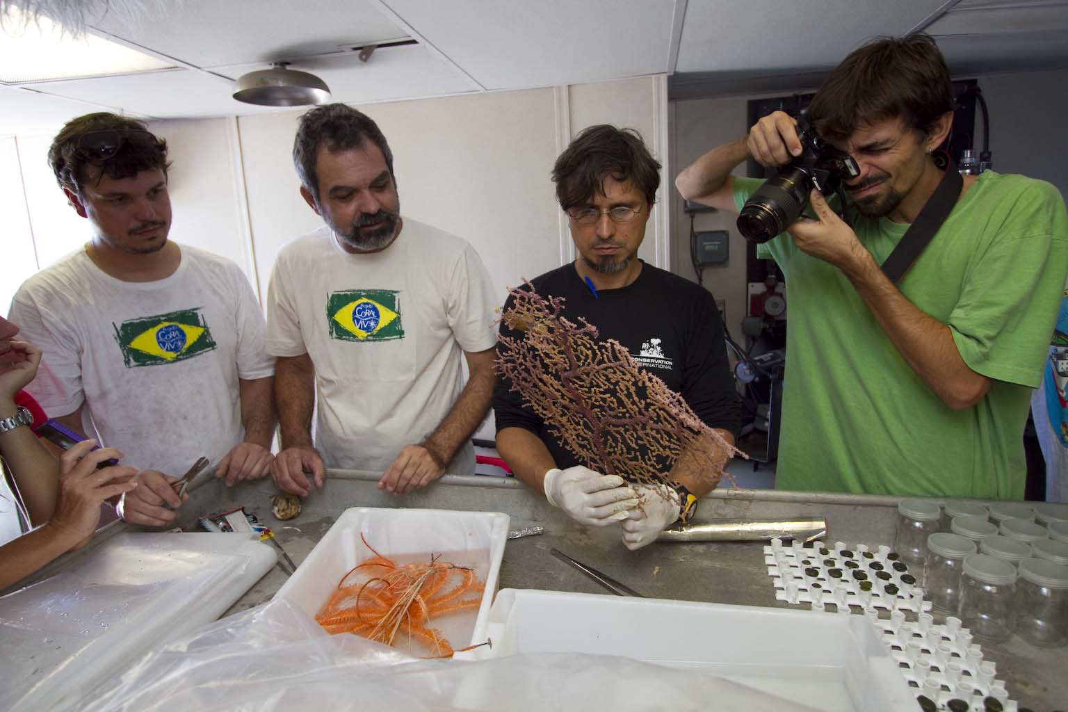
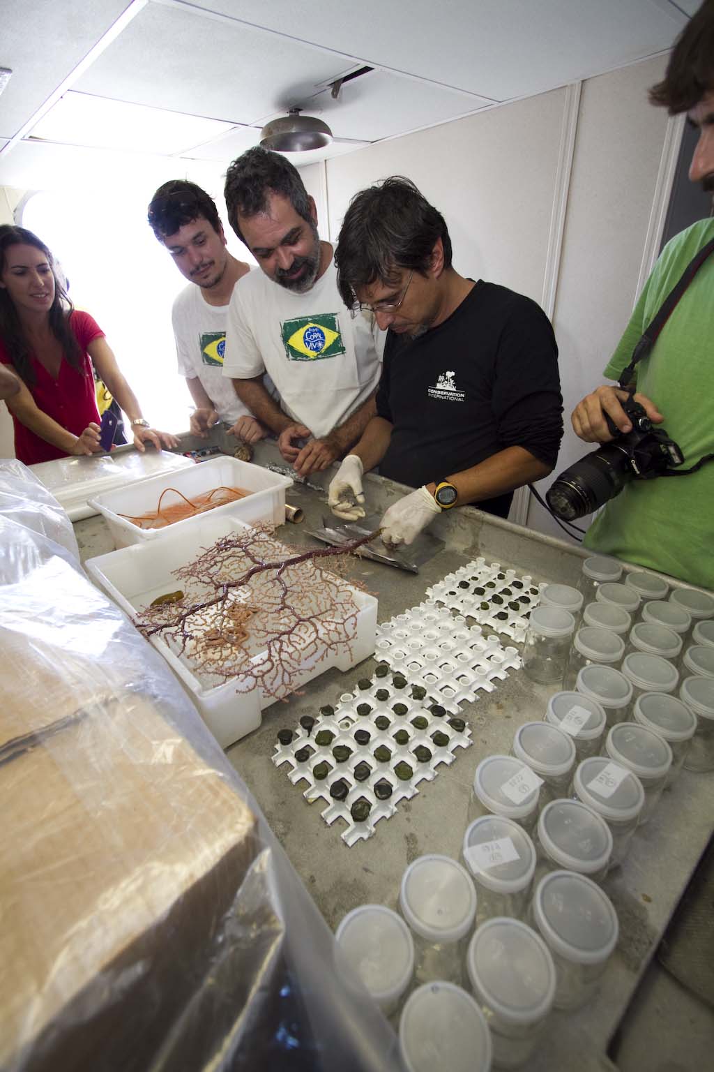
I’ve had several opportunities recently to consider ocean exploration and to do so in light of space exploration and the achievements in both spheres over the last half century.  In Brazil a few weeks ago I had the good fortune to watch engineers from Harbor Branch deploy one of the most well-traveled of all submerisbles, the Johnson Sea Link II.  More recently, I participated in the first annual meeting of the Cooperative Institute of Ocean Exploration Research and Technology in Fort Pierce Florida.  There, some of the brightest minds in ocean exploration discussed all sorts of aspects of modern exploratory oceanography, including HOVs (Human operated vehicles), ROVs (remotely operated vehicles), AUV’s (autonomous underwater vehicles), buoys, landers and sundry other engineering marvels that are helping reveal a deep ocean far more diverse and wonderously engaging than we ever thought possible (like the Okeanos Explorer).  Consider that hydrothermal vents, methane seeps and brine pools were unheard of just a few short decades ago.  The biology uncovered at these sites has revolutionised the way we think about how animals work, especially the unexpected abundance of chemosynthetic organisms - indeed, entire ecosystems  - depending on chemical energy and not the power of the sun.

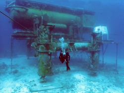
The NOAA Aquarius Reef BaseTowards the end of the CIOERT meeting we were treated to a terrific session where Bill Todd, the project lead for NASA’s underwater training and research program gave an excellent and thought-provoking talk about the parallels of space and undersea exploration.  After it, he and the aforementioned Scott Carpenter and HBOI associate director (and CIOERT principal) Shirley Pomponi held an impromptu panel discussion with the other CIOERT investigators.  In addition to his space missions, Carpenter was also a SeaLab II aquanaut in the 60’s; one of very few people to both orbit the earth and serve a lengthy mission living at depth, so he’s qualified to speak to both topics.  The session was a real treat.  Todd, who is a dynamic and convincing speaker, argued that many of the stated reasons for exploring both sea and space (tech development, resource prospecting, naional defence etc) are little more than smokescreens for the real reasons (to be first, to make a mark, to satisfy curiosity) and yet the real reaons are somehow so much harder to defend against the scrutiny of the uncurious and unscientific.  He also didn’t shy away from the incongruous difference in perception between astronauts as national heroes (thoroughly deserved, of course!) and the unsung status of essentially all undersea explorers.  His best example was that the astronauts with the most hours in space are recognised with uniforms, titles and medals, whereas the aquanauts with the most hours (the ones who maintain the NOAA Aquarius Reef Base off the coast of Florida, the only permanent undersea research station left in existence) are still referred to as “hab techs” (habitat technicians) and fill a service role in support of visiting scientists.

The now-defunct Isis ROV (Southampton UK)At the end of the session I asked the panel the perennial question that now plagues exploratory research in both space and sea: manned or unmanned?  The outrageous success of NASA missions like Cassini, Spirit, Opportunity and Hubble and the near-uquiquity of ROVs and AUVs in modern oceanography (and the dwindling number of HOVs) argue for staying home and letting technology do the hard work.  Somehow though, this just doesn’t sit right with me.  The inspiration of watching Brazilian scientists return from their first dives on Abrolhos just a few short weeks ago simply doesn’t gel with the idea that ROV’s can take over for manned missions to the deep.   Yet the trend is undeniable in both sea and space.  To my relief, Commander Carpenter answered that of course it is a false dichotomy; it’s not an either/or situation.  We need HOVs and ROVs to explore the depths, and AUV’s, and landers, and anything esle the boffins can come up with; we need to do it all, because there’s a lot of ocean yet to explore.  Just the same, we can’t allow space exploration to become the exclusive realm of robots and probes.  At some point there is no substitute for astronaut as geologist-with-a-rock-hammer.

While I agree with Commander Carpenter I am rapidly becoming a shameless HOV fan.  At a time when science so often loses the struggle against the vapidity of pop culture and when so many folks - bloggers included - talk so much game about inspiring young people to pursue careers in science, the human aspects of exploratory research cannot be ignored or allowed to atrophy because of budgetary concerns or rigorous adherence to logic.  There are hardly any active HOVs operating now compared to the explosion of ROVs in recent times, and yet we can’t expect the next generation to be as besotted with technological solutions as we have allowed ourselves to become.  Why should they?, they grew up with technology.  No, there is still room for people to explore, not just machines, and for the Cousteaus, the Piccards, the Links and the Carpenters to inspire the rest by showing us that the emotional/aspirational reasons for exploratory research can compliment the objectivity of the research itself, because they lie closest to the truth of human nature.

Wednesday
Jan262011

Who's nourishing the deep reef?

As we were steaming along yesterday, we encountered a mysterious yellowish slick along the surface.  Sometimes it formed into filaments stretched out like cobwebs on the surface, but in other areas it was thick enough to make the water surface totally opaque.   What could it be, so far off the coast?  fish spawn? coral spawn? algae? oil, maybe? So we slowed the ship and took a bucket sample from over the side (thanks Maurice!).  The culprit? Trichodesmium.  This blue-green alga is common in the nutrient poor waters of the tropics, and occasionally forms huge blooms like this.  How can it bloom when nutrients are so scarce?  The answer is that it makes its own nutrients; Trichodesmium is a “nitrogen fixer”.  This means it can take nitrogen from the air and incorporate it into its own molecules and tissues, a relatively rare feat (the best known example on land are legumes like peas and beans).

If Trichodesmium blooms like this, then the impact can ripple through the ecosystem because, once fixed, the nitrogen is available to the rest of the food chain.  This can make Trichodesmium a key species.

All of that brings us to Dr. Paulo Sumida from the University of Sao Paulo.  Paulo is on this expedition to study organic matter, like the products of all that Trichodesmium.  He’s especially interested in what’s happening on and just above the bottom, where the sub is visiting.  One of the biggest questions: is the organic matter in the sediment of the dark deep made by organisms on the bottom elsewhere and transported there, or is it made by plankton in the water column above (like Trichodesmium), and then rains down like nutrient snow?  One of their other hypotheses is that the southern part of Abrolhos is more productive than the north.  In other words, that more organic matter is produced there by greater numbers of organisms.  To work out the answer to these questions, Paulo looks for clues about how much organic matter there is, what “quality” it is and who made it. 

Dr. Paulo Sumida peers out of a porthole on the JSL sub

Measuring how much organic matter there is is relatively straightforward with an instrument called a CHN analyser (C = carbon, H = hydrogen, N = nitrogen, the key ingredients of organic matter).  To measure quality, Paulo looks at how much of the photosynthetic pigment chlorophyll is present.  If the organic matter is old, most of the chlorophyll will have broken down in a process scientists call diagenesis, leaving behind waste products called phaeopigments.  The relative amounts of chlorophyll and phaeopigments can be used as a measure of the quality of organic matter.  Perhaps the coolest part, however, is trying to work out who made the stuff.  To do that, Paulo uses a rare tool at the University of Sao Paulo, called a GC-IR-MS (gas chromatograph isotope ratio mass spectrometer, say that ten times fast).  This instrument can look for chemical signatures that tell you who made the organic matter.  For example, phytoplankton might produce organic matter with certain carbon isotopes in it, while benthic algae might produce a certain sterol compounds that, when Paulo sees them, he can say “Aha! Now I know that this organic matter was made by this group or that group”. It’s a great bit of detective work.

Taken together, all this information tells Paulo and the other scientists about how nutrients move from water to sediment and back again (properly called “flux”) and therefore how tightly life on the bottom is connected (“coupled”) to life in the water column.  It also speaks to how connected different parts of the bottom may be, especially if organic matter proves to be made somewhere else and then transported to the dark zones.    So what’s the answer? Is it produced on the bottom or in the water column?  By algae or by phytoplankton?  Unfortunately, we don’t know yet, because this is just the sample collection phase; his research is just beginning.  I hope in a future post I can tell you about the results of Paulo’s work.

Wednesday
Jan262011

The Briny Deep - a post by Kristie Cobb Hacke

Yesterday morning on a tour of the bridge of the Steward Johnson following the deployment of the submersible, we had the opportunity to chat with some of the sub crew and a pilot. During our chat they were sharing stories of other dives. One in particular was incredibly interesting to me because it continues the idea of worlds within worlds (the sneeze theory). Craig Caddigan was mentioning that he piloted the submersible to a location in the Gulf of Mexico that contained an “underwater lake.” The lake was a dense brine pool, made up of water with an incredibly high density due to salinity and found at over 2000 feet depth. Craig described landing the sub on the lack and bouncing along the surface and creating ripples. The brine area has its own waves and “beach”, in this case surrounded by a 10’ ring of mussels. The mussels use methane as their primary food source. The submersible was unable to descend into the brine lake because it was too dense, but they did take along some tools that could sample the contents.

A brine pool in the Gulf of Mexico

What is amazing to me is that this brine sea is contained within the ocean. Do the animals that live around this area know that they are living in a sea within a larger ocean? When I sit on the beach am I merely sitting on the edge of a pool within someone else’s greater ocean. Am I at risk of being someone else’s sample? These big thinking questions are what keep me going but the scientists aboard the Abrolhos are focused on the small things that make up the ocean. Right now they are collecting small coral samples, sediment, rock, fish and other items. During the cruise other members of the HBOI staff have been creating maps so that the scientists can use them for future trips or they can clearly note the location of sample and sediment collections. The CTD collected water at the same locations where the submersible was deployed, so that bacteria and viruses can be measured and identified in the water column. The hope is that each of these small pieces can create a larger overall understanding of the structure and biology of the Abrolhos reef.

Wednesday
Jan262011

The moonpool

Generally-speaking, holes in ships are A Bad Thing, but in the center of the R/V Seward Johnson there is a hole, a really big hole, that’s both deliberate and critically important.  It’s called a moonpool and it’s used to deploy the device that allows the Com-Track (see previous post) to talk to the sub: the transducer.  This acoustic tool (basically a combination speaker and microphone) could just be dangled over the side, but the hull of the ship would interfere with the signal, so they lower it through the moonpool well below the ship.  It’s a lot like putting up an antenna, only upside down.  As I stared down into the blue glow, Sully the Com-Track officer was using the transducer to speak to the sub pilot, 800ft further down into the depths below…


PS - If you’re wondering why the water doesn’t rush up through the moonpool it’s because the water in the moonpool is level with the surrounding sea level, so there’s no pressure to push it up into the hull.

Tuesday
Jan252011

A *bit* of a tour of the Johnson Sea Link

Kristie Cobb Hacke and I were given a royal tour of the JSL submersible today, by longtime pilot Don Liberatore.  Unfortunately the ships satellite internet won’t handle the 20+ minutes of 1080p goodness, so these two snippets will have to do.  I’ll splice together the full vid when we get back to a wired internet connection. In the first video, Don describes the sample bucket system and in the second, I poke my head into the rear observation chamber

Tuesday
Jan252011

Taking mapping to a whole new level

When you set out to drive somewhere, or to sail a boat, you put a lot of faith in maps.  You trust that things are where the maps says they are and that there’s nothing where the map says there’s nothing.  Can you imagine the chaos if the map didn’t sync up with reality?  It’s relaitvely easy to make faithful maps for roads because, for the most part, they’re man made, and someone planned and engineered them, so they have good survey data.  But for oceanic charts, its a bit different.  Charts are made by sounding (measuring the depth to the bottom at a specific point) and then joining up all the points of the same depths into contour lines (isobaths).  But because you can’t usually see the bottom over which you sail, you really have to trust that whomever made the chart did a decent job of it.

In this overlain image of two charts, you can see how one (the black lines) does not match the other (coloured lines)

Bill Baxley noticed that some of the charts for the area of the Abrolhos shelf where we are working don’t even match up with each other very well.  That means someone is right and someone is wrong, so Bill - the Harbor Branch director of technical operations for this expedition - is using downtime in between sub dives to better map the bottom.  At night, while the science crew grabs some much-needed shut-eye, Bill and the ship’s crew sail back and forth across the shelf break, taking super accurate readings of the depth using sonar equipment and precisely geolocating the soundings by GPS.  From all these data, he has not only created a much more reliable map for use on future research trips to this area, he’s even able to use GIS software to render the bottom in three dimensions.  In the movie below, Bill animated his map so that you can quite literally see the north shelf break of the Abrolhos platform rotating before your eyes.  He’s even put two submersible tracks on there.  The deeper of the two in red is the one where the bottle was seen, and on which this photo and video post was based.  If this isn’t just about the coolest thing ever, I don’t know what is!

Tuesday
Jan252011

Good old-fashioned home-grown oceanography!

If oceanography had a classic bread-and-butter technique, CTD casts would have to be it.  The C stands for conductivity (basically salinity), the T for temperature and the D for depth.  The “cast” refers to the fact that you measure these three properties as the instruments descend to - and return from - the sea floor.  CTD casts tell scientists about the structure of the water column beneath them.  How can water have structure?  Well, differences in temperature and salinity can lead to layers in the water and these can tell you about how the water is or isnt moving and also have implications for animal life living there.  If you’ve ever swum in a lake where your body was warm but your legs were cold, then you’ve experienced a structured water column, or water layers.  (Strong structure like that often happens in summer when surface waters are warmed by the sun, which makes them less dense, so that they are even more buoyant.  When winter comes, the surface layer cools until it is denser than the underlying water, at which point the surface water sinks and the water column “turns over”)

In a world of side-scan sonar, ADCP and satellite sensing, CTD casts still play a really important role in understanding the water column, so they are still a core part of any oceanographer’s toolkit.  Let’s take a look at one.  This CTD/rosette sampler is part of an instrument package belonging to the Rosenstiel School of Marine Science at the University of Miami:


This rather expensive bit of kit stands about 6 feet high and consist of 24 sample bottles arranged in a ring, with the actual CTD instrument package underneath.  Together, this equipment can make accurate measurements of not only salinity, temperature and depth, but also dissolved oxygen and chlorophyll concentration, AND it can take a 10L sample at any depth using the “rosette” of bottles.  In the following video, U. Miami oceanographers deploy the CTD, then I discuss the acquisition of data with Cepemar oceanographer Carlos Fonseca, and finally graduate student Nelson Alves collects water samples from the sample bottles for a study on bacteria and virus diversity


So far here in Brazil we’ve seen a typical “surface mixed layer”, where the temperature and salinity is the same throughout the top 10-20m.  Below that, temperature drops sharply 4-5 degrees C to a colder underlying layer; this transition is called a thermocline (thermo = temperature, cline = a gradient) and is a standard feature of that well-layered water column.  Below that, temperature drops more gradually, but with some jagged steps that result from “salt fingers”.  These are small-scale turbulence features that tell oceanographers (like Carlos in the video) about mixing processes taking place in the water column.

The CTD - long time friend of oceanographers the world over!

Monday
Jan242011

A sobering sight at 600 meters

On the very first Johnson Sea Link dive during this cruise, the very second thing seen on the bottom was the bottle shown in the video below shot by Johnson Sea Link crew.  This was observed at 600m (technically, it was at 1,850ft), in soft calcareous mud, over 45 nautical miles from land and 60 miles from the nearest town.  On the next dive, the scientists observed a lot of old longline fishing gear wrapped around the reef structure.  It seems, even in this remote location, which has never before been visited by humans, trash from human activities elsewhere has made its mark on the habitat.  It is a prominent and disturbing reminder of our impact on even the unseen parts of the planet.  I can only hope that this bottle becomes a home for some small thing, or that it becomes crusted over with coralline algae such that one day it is simply a bottle-shaped rhodolith

Monday
Jan242011

Eyes in the deep

The medusa lander. Img courtesy Adrian FlynnIt’s nice to hear a familiar Aussie accent from time to time and so it was when Dr. Adrian Flynn joined the Abrolhos expedition.  Adrian hails from Melbourne but was based for a long time at my alma, the University of Queensland, where he applied tools developed in a collaboration between Dr. Justin Marshall at UQ and Lee Frey at Harbor Branch, to study animals in the deep sea.  Specifically, they designed and built Medusa, a “lander” that can be deployed off a ship or from a submersible to sit on the bottom and film animals in a much less intrusive way than would be possible with a manned vehicle.  The keys to the success of Medusa are that it can be left on the bottom for a prolonged period, that it can be baited to attract animals, and that it illuminates the surrounding scene using wavelengths of light that most deep-sea animals cannot sea.  This allows the custom cameras onboard to record animal behaviour without their knowing, which improves the chances that the behaviours recorded will be “typical” and not a response to the presence of the equipment.

The results have been fantastic, as you can see in the video below. In it,  Medusa is shown being deployed in the Coral Sea near Osprey Reef. Stay for the 6-gill shark at the end - it gets all Nom! Nom! Nom! on the tuna head!

Sunday
Jan232011

Diving is like a box of chocolates...

…You never know what you’re going to get.  In this video, the Johnson Sea Link (JSL) is recovered after the first dive of the Abrolhos2011 Expedition.  Brazilian scientist Clovis Castro was aboard with HBOI scientist Shirley Pomponi. 

Afterwards, the science team went to work processing invertebrate samples including gorgonians, the hard coral Lophelia, and a range of brittle stars, crinoids, urchins and miscellansous crustaceans

The Brazilian science team evaluates their first samples. L-R Gustavo Duarte, Clovis Castro, lead scientist Rodrigo Moura and Ronaldo Francini-Filho


Reporter Glenda Koslowski with Brazilian scientists (L-R) Gustavo Duarte, Clovis Castro, Rodrigo Moura and Ronaldo Francini-Filho


PhD student Gustavo Duarte takes Lophelia fragments for cultivation

 Alex Bastos with a fine carbonate mud sediment core from 600m


Sunday
Jan232011

Day 1 cruise track

Here’s our Day 1 cruise track, taking us from Nova Viçosa out to a way point and thence to the R/V Seward Johnson.  Right click the link and save, then  open in Google maps or Google earth

Saturday
Jan222011

Welcome aboard!

Friday
Jan212011

Getting down to the nitty gritty

How deep can we go?  How can we collect fish?  How much water can we sample at once?  These are just some of the questions that filled today’s planning session in Vitoria for the Abrolhos 2011 expedition.  They’re not straightforward questions to which some resident authority has a simple answer.  No, when you’re planning work between 300 and 3000 feet down, no questions are simple, and nor are the answers easy; rather, they are crafted through a careful group discussion of what’s a priority, what’s possible, what’s practical, and what we have time for.  In other words, its not all The Life Aquatic, its large parts careful planning and preparation.

The day started with presentations from representatives of Cepemar, Harbor Branch and the Rosenstiel School of Marine Science at U. Miami.  After that, Rodrigo Mouraled the planning session where we talked reef biology for hours, fueled (as all the best science chats are!) by shots of excellent Brazilian coffee.  Dr. Moura is a faculty member at Santa Cruz University and a consulting scientist with Conservation International, who have a substantial marine conservation program focused at Abrolhos.  He explained all the things that make Abrolhos unique, from the 40,000km2 platform on which they occur, to the unique fauna and dominance of shallower reefs by the endemic coral Mussismilia braziliensis, to the unusual mushroom formation of these reefs (chapeiroes), and finally to the history of human impacts and conservation efforts surrounding these unique ecosystems and the deeper and less-known seafloor habitats around them.  The Abrolhos Marine National Park was the first marine national park in Brazil, established in 1983, but like many reefs it faces its fair share of threats from pollution, global climate change and marine development.

 Suitably up to speed on the history and context for the expedition, the next speakers were the 8 principal investigators to give details of the motivations for their respective parts of the expedition, and to outline their specific sampling needs.  Alex Bastos, a geologist from the Federal University of Espirito Santo, talked about the geological history of the platform, how its central depression was likely once a shallow coastal lagoon during the last ice age, and how taking samples of sediment from the bottom will explain more about how the reef came to be and how much it contributes to calcium carbonate production in that part of the Atlantic. Paulo Sumida from the University of São Paulo explained how organic matter (carbon based material either secreted from living organisms or leftover by dead ones) is distributed unevenly across the platform, with more in the south and less in the north.  We learned from Mauricio Torronteguy’sgroup at Cepemar how water sampling and measurements of the properties of the water overlying the reef would be used to provide a better understanding of the biology taking place on the reef.  Microbiologist and geneticist Fabiano Thompson from the Federal University of Rio de Janeiro explained what has been learned about the importance of Vibriobacteria on the reef, both as potential agents of disease in corals and, surprisingly, as possible agents of photosynthesis; i.e. food production from sunlight.  Vibrios were not previously known to use light for food, so this is potentially big news.  His graduate student, Nelson Alves, will be sampling for water-borne viruses by looking for their DNA signature.  These aren’t viruses as we know them (causes of A rhodolith bedhuman disease), but a natural and dominant part of the very smallest members of the plankton, whose importance has only been realized in the last few years.  Gilberto Filho, who is a head botanist at the Botannic Gardens in Rio de Janeiro, talked about the importance of rhodolith beds, which are an unusual sort of habitat made up of softball-sized lumps of reddish rock that are produced by algae that are able to secrete calcium skeletons as they photosynthesise, much like corals do.  These lumps then become substrate for all manner of other things to live on, since they are hard and rigid, unlike the soft, shifting sediments on which they sit.  In this way, rhodoliths can increase the diversity of a patch of otherwise empty seabed.  Ronaldo Francini-Filho talked about what is known and not known about some of the bigger critters that make up the reef community, like fish and larger invertebrates.  The final presentations from National Museum scientist Clovis Castro and student Gustavo concerned deep-sea corals of the Abrolhos, including those that use light and have symbiotic algae in their tissues (zooxanthellate) and those that lack algae and feed by filtering plankton or absorbing organic material directly from seawater (azooxanthellate).  We’ll learn more about each of these projects in coming days, so if you have questions for the researchers, by all means post them in the comments below. 

The hardest part of planning a research trip came next: deciding how on earth we’re going to meet everyone’s needs within a limited timespan, using the assets of the ship and the brain trust of people aboard it.  This is where the beautiful ideality of a proposed sampling scheme meets the stark and sometimes gruesome reality of what you can, practically speaking, actually do.  All scientists, especially biologists, know and dread this bit; indeed, Mmmmm…mesophotic reefs…argleargle….a lot of the very best biologists are those that have mastered this challenging process and can come up with intelligent and efficient sampling schemes that provide maximum bang for the research buck and minimize down or wasted time.  The upside of this process is that as everyone thinks and talks, you start to see the days to come materializing before you, and a sense of very real excitement sets in.  Ahead lie mornings spent deploying the submersible, afternoons sorting samples of sediment, deep sea corals and sponges, and evenings spent measuring water column properties with a CTD/Rosette and ADCP (more on these later).  It’s enough to make any marine scientist practically drool with anticipation.