Navigation
Twitter and News feeds
Search this site
Networked Blogs

Entries in NOAA (11)

Monday
Jan242011

Putting the world's commercial ships to work

The University of Miami’s Peter Ortner calls the Royal Caribbean cruise ship Explorer of the Seas” the world’s most luxurious research vessel”.  That’s because he and his colleagues affixed instrument packages and even built a small lab on the luxury liner.  Why do this?  Well, if you think about it, cruise ships and commercial ships are criss-crossing the oceans all the time.  What an awesome opportunity to collect data!

Commercial shipping lanes of the world - the ultimate scientific transects?

One of the best sorts of data that Peter’s team collects is called ADCP, for Acoustic Doppler Current Profiling.  Its a sonar method of sorts, but not for measuring the distance to the bottom.  Instead, it can tell you the direction and strength of the current (i.e. its vector) at every depth under the ship.  That’s because the speed that sound travels through the water is distorted by current the same way that the speed of sound through air is distorted by speed (you hear this as, for example, the change in pitch when an ambulance goes by). 

ADCP current vectors (black arrows) recorded by a ship and mapped on temperature of the Gulf Stream. You can see how well they match up

By putting a bunch of ADCPs on a bunch of different ships that cruise regular paths, oceanographers can build up a very detailed picture of currents across ocean basins, on a scale that individual oceanographic vessels could never match.  Along the way, they have discovered new features, especially eddies of various sorts in some unexpected places.  An eddy is a circular current, sort of like a gentle cyclone in water; sometimes they form by themselves, but more often they spin off the edge of a current as it passes through another body of water; these are called frontal eddies.  Eddies can go clockwise or anti-clockwise and they can have a warm core or a cold core or a ring-like structure, depending on how they form.  Eddies are important because they profoundly affect the biology within them - either stimulating or dampening productivity.  They can also be really important for weather and climate, because an eddy can take a lot of heat energy from a warm current like, say, the Gulf Stream, and move it somewhere else.  Climate and weather prediction models work much better when eddies are properly accounted for.

What an eddy looks like by ADCP. The ship travels left to right across the top. Red pixels is where water is coming towards you out of the screen, while blue is it going away from you, into the screen


ADCP also gives you BIOLOGICAL data. Here, backscatter shows variations in the distribution of plankton as the ship crosses an eddy like the one in the previous figure

The idea of using commercial ships to collect oceanographic data has proven popular and now a UN committee is working on an implementation plan that would see many ships constantly gathering oceanographic data in all the oceans of the world.  That program is called Oceanscope, and when it reaches maturity, Peter’s dream would have become and reality and he can kick back and watch the data roll in.


Tuesday
Nov092010

Follow this NOAA expedition on a new "Deep Corals" blog

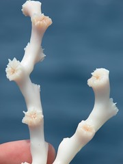
Lophelia, a deep sea coral.Fun news from colleague Andrew Shepard at Harbo Branch (Florida Atlantic U.), via Kim Morris-Zarneke:

“Tomorrow, Nov. 9, 2010, the NOAA ship Ron Brown departs Pensacola, FL, on the Extreme Corals 2010 Expedition. Chief scientists, Steve Ross, UNCW, and Sandra Brooke, Marine Conservation and Biology Institute, lead the effort to explore and characterize deep coral ecosystems from the West Florida Shelf to the northern Florida east coast using WHOI’s Jason ROV. We have set up a Web portal for the expedition at http://cioert.org/xcorals. The NC Museum of Natural Science is partnering on this web offering, providing access to daily blogs from sea, image gallery, education materials and more at http://deepcoral.wordpress.com

Thursday
Jul152010

Okeanos footage

National Geographic is hosting some nice footage of a submarine volcano in Indonesia.  The video was gathered as part of the Okeanos Explorer and its current collaborative research cruise between NOAA and the Indonesian Government

The footage shows some impressive fields of stalked barnacles, an abundance of shrimp and some really cool sulfide chimneys and elemental sulfur flows.

Friday
Jul022010

Implications of the first sighting of whale sharks in the gulf oil slick

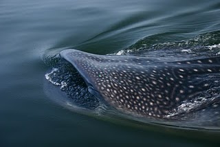
I recently experienced a moment of genuine dread regarding the oil spill in the Gulf of Mexico, and it was neither a familiar nor comfortable feeling. What is it that invoked such a powerful feeling after a disaster that has been underway for the last 80-odd days, now? Something that struck a little close to home, of course: the first direct impact to whale sharks. You may have seen this story coming across the wires over the past two days about NOAA scientists who, while on an aerial survey of the impacted area, observed 3 whale sharks swimming among ribbons of surface oil, not 4 miles from the epicenter of the Deepwater Horizon spill. This observation has serious implications; let me explain.

Whale sharks are widely-ranging tropical migratory sharks that are unusual among their more toothy relatives in that they eat plankton. Two of the adaptations they use to pursue this lifestyle – surface filter feeding and an exquisite sense of smell – make them especially susceptible to the impacts of the oil spill. I had all but convinced myself (perhaps wishfully thinking) that whale sharks would be able to sense the altered chemistry of the affected water bodies and avoid the area. It now seems that this is not the case; the observation by the NOAA scientists suggest that either whale sharks cannot tell the difference between polluted and unpolluted water, or they can tell the difference but do not alter their behaviour in such a way as to avoid the ribbons and plumes. As USM researcher Eric Hoffmayer states in the article, this is the realization of the worst fears of whale shark scientists, and I count myself among those.

How can it be that whale sharks are unable to tell the difference if their sense of smell is so good? One simple explanation is that the olfactory abilities may be extremely selective. Scientists don’t know exactly what sort of chemicals whale sharks are homing in on when they seek out patches of food in the ocean – indeed, addressing this question is one of the goals of this year’s whale shark research program at Georgia Aquarium – but we have some good candidate molecules. If the whale shark sense of smell is highly tuned to these compounds and relatively insensitive to other families of chemicals, like hydrocarbons (oil and gas), then it’s certainly possible that whale sharks simply cannot detect the problem.

That’s when the second adaptation, surface filter feeding, becomes a liability for whale sharks trying to negotiate the deadly emulsions and surface slicks in the Gulf. To fully appreciate why this is such a problem, we need to look a little more closely at the filtration apparatus whale sharks use to feed.

Like most plankton-feeding fishes, whale sharks use filters in the mouth/gill cavity to sift food particles from the water (see the exellent illustration by Emily Damstra at right). And like most plankton-feeding fishes, these filters develop from structures associated with the gills and gill rakers (cartilaginous rods that come off the leading edge of the gills and protect the gills from fouling and shape the current of water across the breathing surface). Where whale sharks differ radically from other planktivores like, say, anchovies, is that they do not have feathery interlocking gill rakers that serve to filter the plankton but can be disengaged from each other to allow bulk water flow out through the gill opening. Rather, their filters are so derived and so heavily branched that they form a single continuous pad that occupies the space between gill arches; it looks a lot like a black scouring pad. The gill arches cannot be disengaged from each other; thus, anything that goes in the mouth must be small enough to pass through the filters (less than 2mm, or about 1/12th of an inch), or it must be swallowed, or be spat back out through the mouth (something they are surprisingly good at!). In a paper currently in the review process, comparative anatomist Phil Motta from USF is describing the full functional anatomy of these structures; he took the photo of the filter pad surface shown hereabouts based on material samples from Georgia Aquarium.

The implication here is that oil that finds its way into the mouth, if it is not to be swallowed or to foul the filters, must be continually spat back. OK, I hear you say, perhaps if the whale sharks avoid feeding, there won’t be a problem. If only it were that easy. Whale sharks do not only use their mouths for feeding, they use them for breathing. They need to be passing water continually across the filters and thence across the gills, in order to keep the body supplied with oxygen. For the whale shark swimming in oil-affected waters, therefore, the animal’s breathing needs and the susceptibility of their feeding filters to fouling are in complete opposition.

If whale sharks are swimming into oil-polluted waters and fouling their filters with oil, what does that mean? In my best estimation, it means that the oil spill represents an extremely serious threat to whale shark health. I am by no means the first person to suggest this. Nature identified whale sharks as one of the 5 species most likely to be affected by the oil spill, and other scientists like Bob Hueter from Mote Marine Laboratory have also highlighted the risks. The true toll that the spill exacts on the Gulf of Mexico whale shark population will not be known for some time, but the thought of dead or dying whale sharks sinking silently into the depths (dead sharks generally sink, not float) is yet more motivation to put an end to the spill and to undertake immediate and extensive research and conservation programs to assess the damage and plan a road to recovery for the whale sharks – and all the other affected wildlife – in the Gulf of Mexico.

Thursday
May202010

12,081ft - The oceans, by the numbers

I was inspired by recent articles highlighting a revised calculation of the ocean’s average depth as 12,081ft, to consider the seas in a numerical light today. To that end, here’s a few random, sourced numbers and back-of-the-envelope calculations that might be food for thought:

0.87% = Amount we can see by diving from the surface (about 100ft) over the average depth
0.28% = Amount we can see by diving over the deepest part (Challenger Deep, Marianas Trench off the Philippines)
2.9 = Number of times deeper the deepest part is, compared to the average.
5,400 = Number of mammal species in the world
25,000 = Number of fish species in the world
Millions? = Number of marine invertebrates species in the world (no-one really knows)
2.3 Million = The number of US citizens directly dependent on ocean industries (source: NOAA)
$117 Billion = Value of ocean products and services to the US economy (yr 2000, source: NOAA)
50% = US population living in coastal zones
48% = The proportion of all human-produced CO2 absorbed by the oceans in the Industrial era (NatGeo)
0.1 = The pH drop in the surface oceans since 1900
0.35 = Expected pH drop by 2100 (source)
18 = The number of times more heat absorbed by the oceans than the atmosphere since 1950 (source - TAMU). Global warming is an ocean process far more than an atmospheric one.
3.5 Million = Estimated tons of plastic pollution circling in the Great Pacific Garbage Patch, and growing.

And yet:

30 = Number of times thicker the atmosphere is (out to the “edge of space” about 60 miles) than the average ocean. That would be the atmosphere that astronauts describe as a “thin veneer” on the planet…
0.06% = Thickness of the average ocean, compared to the radius of the earth. I think we can argue that the water is the veneer, not the air
$4.48 Billion = NOAA’s 2010 budget, including the National Ocean Service, Weather Service and Fisheries Services. (source NOAA)
$18.7 Billion = NASA’s 2010 budget, i.e. 4 times the size of the agency that looks after our own planet (source NASA)
$664 Billion = Department of Defense base budget 2010, not counting special allocations (source DoD)
0.6% = The amount you would need to cut Defense in order to double the NOAA budget

Some sources:
http://www.corporateservices.noaa.gov/~nbo/FY10_BlueBook/NOAAwide_One_Pager051109.pdf
http://www.corporateservices.noaa.gov/~nbo/10bluebook_highlights.html http://news.nationalgeographic.com/news/2004/07/0715_040715_oceancarbon_2.html  
http://oceanworld.tamu.edu/resources/oceanography-book/oceansandclimate.htm
http://web.archive.org/web/20080625100559/http://www.ipsl.jussieu.fr/~jomce/acidification/paper/Orr_OnlineNature04095.pdf  

Sunday
May092010

Oill spills and Tar balls – know thine enemy

One of the more intriguing aspects of oil spills, including the DeepWater Horizon spill currently unfolding in the Gulf of Mexico (DeepSeaNews has covered it well), is the formation of tar balls.  These are globby blobs of bitumen-like material that are found on the sea floor or washed up on beaches after a spill. There's a few theories about how they form, but the general concept is that as the more volatile parts of the oil mixture evapourate, the mixture becomes thicker, heavier and stickier, until eventually the blob becomes heavier than seawater and sinks. On the bottom, the sticky blob incorporates sediment and its ball-like shape is reinforced by the rolling actions of currents or surf, in much the same way as you roll cookie dough into balls before putting them on the baking tray (mmmmmm….cookies….ahem). Sometimes this process makes for a grainy crust on the outside and a soft center, a bit like a Ferrero Rocher (mmmmm....chocolate....why do my analogies always involve food?).  There’s some other theories of formation that concern flocculation (oil sticking to clay) and emulsion (oil and water making a mousse of sorts - again with the food), but the prevailing idea seems to be that of smaller blobs of weathered oil coalescing and incorporating sediment. The net results is a gooey mess that is characteristically hard to remove if it sticks to you (or an animal), pongs of petroleum and is generally unpleasant.  The photo at left from NOAA's image library shows a tarball on a beach in California

Other than their B-grade horror movie nature (The Blob – aiieeeeee!) and the formation process above, I confess not knowing much about tar balls, so I went to the literature to see what’s out there. The answer: not much. A Web of Science search for “(tar ball) or tarball” 1945-2010 gets you precisely 26 hits. Now that is interesting! I would have thought that there would be far more, given the attention that is focused on oil spills when they happen. Much of the research has focused on chemical fingerprinting to identify where a given tar ball originated. In other words, the presence and absence of certain chemicals in a tar ball can tell you what sort of oil the ball formed from, and pretty accurately too. This has allowed some other studies that have shown that you have to be careful about blaming all the tar balls on a beach on one spill; there’s often a pretty good background level of tar balls from previous spills and even natural sources of oily substances. This is especially so for really small tar balls in the mm size range.

So what’s the long-term prognosis on tar balls in the environment? It doesn’t look like that question has been thoroughly answered yet.  Clearly they persist long after many more obvious signs of oil are gone.  Its tempting to think that they may be largely inert, especially those that form a good crust on the outside that reduces stickiness and prevents chemical interactions with the outside. But really, it seems like there’s a lot more work that needs to be done to understand these curious byproducts of oil spill accidents.

Tuesday
Mar302010

Ocean Conveyor running AMOC

This post was chosen as an Editor's Selection for ResearchBlogging.orgResearchBlogging.org

If you’ve ever seen the disaster movie “The Day After Tomorrow”, then you’ve been introduced to the idea that one day the global ocean conveyor might stop.  Its a pity (or perhaps not) that the movie was such a sensational introduction to the concept, because its a pretty serious possibility.  By way of short explanation: one of the things that makes life possible on this rock is that the ocean redistributes heat that arrives on the earth’s surface between the tropics, sending it to the higher latitudes by way of warm surface currents.  There, the waters are cooled and made more dense (both colder and saltier) by the polar ice caps; they then sink and begin a slow meander back to the tropics, eventually returning to the surface to complete the cycle.  Without effective redistribution of this sort, the tropics would bake and the polar zones would sink into a deep hard freeze (in both cases much more so than “normal”).  The climate in the UK, for example, would be much more like Siberia were it not of the tempering effects of the Gulf Stream continually bringing heat from the Caribbean to the North Sea.  An important point about the conveyor is that it is driven from both ends: by the suns heat near the equator and by the cooling effect of all that ice at the poles.

 Why would the conveyor grind to a halt?  The equatorial heat doesn’t show any sign of stopping; if anything its getting hotter.  No, the biggest fear is for the other driver: if the polar ice caps melt too much, there will no longer be a big enough reservoir to chill and brine the surface waters and they will cease to sink.  Some data from recent years suggested that this was happening, and happening fast.  Well, it seems as though Armageddon isn’t here just yet.  A new paper by CalTech/NASA’s Josh Willis in the journal Geophysical Research Letters uses a more complete data set than ever before to conclude that the conveyor, or more specifically a major section of it called the Atlantic Meridional Overturning Circulation (AMOC - hence the corny title of my post) measured at 41°N (near where it says “Atlantic” on the figure above), is not slowing.  In fact, there is some evidence that it may have sped up marginally in recent years, perhaps in response to warming and expansion of Atlantic waters.  The data were consistent across both satellite sources and sensor arrays deployed in the oceans, so it would seem like a pretty robust study (though I am no physical oceanographer).

I am sure I speak for everyone on the bonnie British Isles when I heave a sigh of relief.

But wait?  What light through yonder ice-shelf breaks?  Tis Greenland, and its seeing more of the sun!  In the very same issue of Geophysical Research Letters, a different group of authors report that ice loss is increasing from the Greenland ice sheet.  This is one of the major impacts of recent climate warming and the greatest contributor to increases in sea level globally.  It would also freshen the north polar waters, further reducing the driving force behind the global ocean conveyor.


My response to this news is to marvel at - and grapple with - the complexity and dynamics of the earth and its climate system.  Scientific results with seemingly opposite implications can come out (in this case in the same journal issue), but without threatening the major underlying pattern; I doubt, for example, that Dr. Willis would disagree with the concept of man-made climate change.  Faced with this seeming contradiction, its perhaps no wonder that many folks grapple with the Big Ideas at the heart of global climate change, and even doubt that it exists at all.  I for one have no doubt  that things are changing, and changing fast.  It may just be that some of the really big features of the climate system (including ocean currents) are slower to respond than others.  Its a bit like turning an oil tanker, which may be an unfortunately apt analogy…

Willis, J. (2010). Can in situ floats and satellite altimeters detect long-term changes in Atlantic Ocean overturning? Geophysical Research Letters, 37 (6) DOI: 10.1029/2010GL042372

Khan, S., Wahr, J., Bevis, M., Velicogna, I., & Kendrick, E. (2010). Spread of ice mass loss into northwest Greenland observed by GRACE and GPS Geophysical Research Letters, 37 (6) DOI: 10.1029/2010GL042460

Saturday
Mar272010

The ghost of fishers past

The folks you see out on their boats on the bay are not the only ones fishing; those who came before them still get a slice of the action, as this recent article about the retrieval of "ghost gear" from the Chesapeake Bay illustrates.  In many trap-based fishing industries, like lobsters and crabs, a significant number of traps are lost during the course of regular fishing efforts.  In addition, when a fishery turns bad, as happened in the Long Island Sound lobster fishery in 1999, some fishers cut their losses, and their marker floats, quit the fishery and just leave their gear where it is on the bottom of the bay.

The problem is, ghost gear like this keeps on fishing, long after the fisher has moved on to other endeavours.  The design of the trap continues to attract animals, even without bait, because the trap is basically a refuge or cave.  Those that enter are unable to leave and as they die they may act as bait to attract yet more animals to feed on their body.  In this way, the trap becomes a sort of "biomass black hole", sucking in animals from all around, for as long as the trap holds together.  Nets can ghost fish too, especially gillnets or any kind of trawl that can trap fish or strangle a reef

We used to trawl up ghost lobster gear all the time when I was working in Long Island Sound.  Indeed, few days on the water went by without snagging someone's old gear at some point, which speaks to the density of gear that's out there in some inshore waters.  I'm glad the fishers and the resource management agencies are working together to address the problem, because its one of those awful chronic out-of-sight, out-of-mind issues that can erode a fishery despite everyone's best efforts to manage things properly.  If you find ghost gear, call your local DEP or DEC, even the EPA, and let them know so they can come and retrieve it.

Picture of ghost gear on a coral reef from NOAA

Friday
Mar262010

Lionfish - more spectacular than your average invasive, but still a right pest.

When we think of invasive species, flamboyant fish from coral reefs are not usually the first thing that comes to mind.  Indeed, if you put together a list of characteristics of successful invasive species (like this one), "boring" would probably be close to the top, along with being quick to reproduce, not fussy about what you eat, having a large natural range, a great tolerance for extremes in the environment, and lacking natural enemies such as predators or parasites.  Think of some of the most successful invaders and decide for yourself if these predictions hold true: carp, starlings, mosquitofish, rats, sparrows, mice, rabbits, dogs, cane toads, cats, foxes, kudzu, chickweed... 

All this makes the invasion of the Atlantic seaboard by the Pacific lionfish, Pterois volitans, all the more remarkable.  Lionfish are flat-out spectacular!  Long prized as an aquarium specimen, they have bold stripes that spill over onto their fantastically long and showy fins; their scientific name even means "fluttering wings".  The sheer beauty of lionfish doubtless plays a role in how they came to invade the Atlantic in the first place; most likely they were an escaped or released aquarium species that found itself able to survive quite nicely in the conditions of the coastal Atlantic.  The beauty of lionfish conceals a dangerous secret - venomous spines on their dorsal (back) and pelvic (bottom) fins.  While they won't kill a person; they cause excruciating pain.  I've never been stung by one, but I have been stung by related scorpionfish (most recently the short-spined wasp fish) and the feeling is not one I'd care to go through again!

Over the course of just a few years, mostly since 2000, lionfish have spread dramatically along the coast of the Atlantic, from North Carolina down to the southern Caribbean and Mexico's beautiful Yucatan peninsula.  Typically considered to be a rocky or coral reef species, they've now been found swimming in the intracoastal waterway; that labyrinth of salt-marshes, channels and estuaries, engineered to allow safe passage of boats along the US coast in wartime.  This is sort of an unusual location, but it speaks to the adaptability of this remarkable fish.

So, what to do about such an animal??  Well, that's a tough one.  Invasive species (or more accurately, moving species around) are one of the greatest impacts humanity has had on natural environments, and there are very few cases where we have successfully eradicated or controlled an invasive (but see prickly pear in Australia), more often they just become part of the furniture and we get used to their impacts on the local ecosystem.  Introducing natural enemies (diseases, predators) like they did for prickly pear is a dangerous game; if you tried to get the Cactoblastus moth introduced to Australia in these days of stricter biosecurity, you'd almost certainly be denied.  You can easily get into a "spider to catch the fly" situation too; in fact that's how cane toads were introduced to many places - to control sugar cane beetles (which they suck at).  Perhaps the best approach is to do what we do best - create a market that will promote human efforts to exploit them, and then rely on the Tragedy of the Commons to do the work for you.  This has already been proposed with Asian carp.  Fortunately, it turns out that lionfish are not only spectacular aquarium fish, but also delicious in a white wine sauce.  I am sure that if we set our minds to it, we could do as good a job wiping out this species as we have with so many others.  So c'mon everyone and grab a fork; Save a reef - eat a lionfish, today!

(Photo and graphic from NOAA)

Monday
Mar222010

What do expectant parents and the Chilean earthquake have in common?

The recent Chilean earthquake was a disaster on a mind-boggling scale; one that had its genesis beneath the sea.  The temblor, and all those in Chile before it, including the biggest ever recorded anywhere, resulted from the Nazca plate sliding down under the South American plate, under the sea to the South West of Santiago.  Well, it doesn't exactly slide, I always imagined it would sound like a creaking door if you could speed up the process a few zillion times.  The upward pressure this collision puts on the South American plate is immense and produces the longest mountain range in the world, the Andes.

Anyway, this most recent slip, which shifted about 10 meters and registered 8.8 on the Richter scale, caused a small tsunami.  Now some researchers from Scripps and UCSD want to know whether it was because of the sea floor movement itself, or because the quake triggered undersea landslides ("slumping") that produced the wave.  They are going to do some nifty multi-beam sonar work to map the seafloor changes in unprecedented details.  Sonar technology has become a really cool tool these days; the same sorts of benefits that new parents reap when they ultrasound their new bundle of joy also give scientists a fantastic new view on the sea floor.  Just check out this example of a shipwreck revealed by NOAA's nautical survey side-scan sonar.

Tuesday
Dec152009

Feral fish

No, not the long-haired hippy type, I mean those that are not indigenous to a habitat.  USGS and NOAA just co-published a pictorial guide to the non-native fishes of Florida.  This is doubtless part of the heightened awareness of this problem in US waters and, indeed, worldwide.  Lord Robert May recently cited invasive alien species - along with climate change, over-exploitation, and habitat destruction - as the most important causes is species extinctions in the biodiversity crisis.  It seems marine species are not immune to this effect; even though the diversity-stability hypothesis predicts that reefs ought to resist invasions.

My PhD thesis was about what happens to the parasite fauna when a fish gets introduced to a new habitat, so this subject is close to my heart.  To learn more, read about the subject as reviewed by my colleague Mark Torchin here: