Networked Blogs
Search this site
Twitter and News feeds
Navigation

Entries in Australia (18)

Wednesday
Feb022011

Tropical Cyclone Yasi

As if Queensland hasn’t had a bad enough year already, the half of the state that was spare the flooding earlier this month is now about to be hammered by one of the largest tropical cyclones (read hurricanes, US friends) ever recorded.  In this post I just want to gather together a couple of bits and pieces I’ve seen about the web.  If you want to follow it as it unfolds, the best Twitter hashtag is #TCYasi and the ABC (Australia’s nationally sponsored TV network) has a live blog here.

Here’s Towsville 6hrs before the storm crosses the coast:


 Here’s the predicted storm track from the Australian Bureau of Meterology.  It has Mt Isa - a dusty inland mining town in the middle of nowehere, getting a Cat 1 cyclone hit, which is surely a first!

Here’s the most recent (at time of writing) WeatherChaser satellite image of Yasi. Click the image to embiggenate:

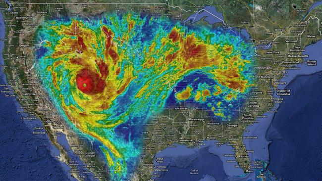
If you struggle with the scale on that image, here’s what Yasi would look like sitting over the US.  It is a truly gargantuan storm.  Click the image for comparisons to Asia and Europe.

Here’s the final press conference given by Queensland premier Anna Bligh before the storm comes ashore.  Its quite long and raw.  She starts speaking at 3:24.  In it she states that the city of Townsville has lost power, which is where several evacuation centers.  She also passes on a little science; talking about the unreliability of wave buoy readings off Townsville, where the buoys are being swamped by waves.

Monday
Jan242011

Shedding some light on lanternfish

Diaphus parri, a lanternfish from the Coral Sea. Img: Adrian Flynn

Adrian Flynn’s PhD is about myctophids, or lanternfishes.  These are not well known to most people, but they’re probably among the most abundant animals on the planet, because they live in the largest habitat there is: the deep mid-waters of all the oceans of the world, neither near the surface nor on the bottom, what scientists call the mesopelagic zone (meso = middle, pelagic = in the water column).  Lanternfish, as the name implies, produce their own light from organs arrayed on the skin of the head and body.  These organs, which generate light through the action of the enzyme luciferase, allow the fish to signal each other, to find food and to disguise their own outline against the gloom from above, when seen from below.  Its a neat trick, but not nearly unique in the deep pelagic zone.  Indeed, it seems that just about everything down there makes light in some form or another (if you want some google fodder for that, check out Edith Widder’s work, she’s got a great talk on Ted.com too).  Lanternfishes can be hard to study because they’re hard to collect in tact; they’re sort of flabby and the skin comes off very easily. But not to be deterred, Adrian is undertaking an ambitious study of how different species of lanternfishes are distributed from the tropic of Capricorn to the waters of the Antarctic - their biogeography - and also how the numbers of any given species are affected by oceanographic factors like major currents and places where deep nutrient-rich water comes up to the surface (upwelling). 

A nice ventral view of D. parri, showing the light organs arrayed on the skin

So far his results are showing that the deep pelagic zone is not as homogenous as previously thought.  It seems that lanternfish distribute themselves into biogeographic zones somewhat according to latitude, but more so according the oceanographic features like major currents and landforms like islands.  He’s had a couple of real eye opening results too.  In one case, they observed - for the first time in Australia - a lanternfish spawning aggregation, off the coast of Cairns in far north Queensland.  That’s cool, but what was a real trip was that the laternfish in question (the Dana lanternfish) was a species known only from Tasmania, almost 2,000km away!  How did they get up there?  How will their young get back again?  On another expedition, they found lanternfish close to the surface at Macquarie Island, a remote rock in the Great Southern Ocean.  The island juts up into the prevailing currents, causing upwelling that brings nutrients and lanternfishes alike well within the foraging range of penguins and seals/sea lions that nest on the island.  It looks like lanternfish in this unique location are an important part of the diet of at least three penguin species as well as the pinnipeds (seals), and that’s a pretty novel discovery.

Thursday
Jan202011

The start of something beautiful

My travelling partner Kristie Cobb (Georgia AquariumVP) and I arrived in Brazil today for the Abrolhos 2011 expedition.  The flight in from Atlanta is long (10hrs) and a red-eye, so we arrived a little the worse for wear in Rio.  As we flew, I was considering the similarities and differences between Brazil and Australia.  Brazil’s great mountain range is to the west and is immense in both length and height: the Andes.  It circumscribes the Amazon basin, the most spectacular crucible of biodiversity on the planet.  It drains to the eastern seaboard, which has some coral reefs (including the ones we’ll survey), but nothing like the Great Barrier Reef.  By contrast, Australia is mostly a giant flat arid zone (Google the awesomely ominous sounding “yilgarn kraton” to learn more) with its “great” mountain range on the eastern coast, where a once-active subduction zone scraped off enough Pacific sea floor to make a strip of lan on which >75% of Aussies live.  I say “great” because even the highest of the Snowy Mountains is a pimple compared to the Andes.  There are rainforests in appropriate microclimate pockets along the great dividing range, sure, but not like the vast unending ones we flew over today; there just isn’t the volume of reliable rain (recent floods notwithstanding).  Partly as a result of that tiny eastward drainage and low rainfall, the tropical coastal waters of north eastern Australia are nutrient poor and therefore ideal for coral reefs; accordingly, the Great Barrier Reef is the Amazon rainforest of reefs.  They are two countries with priceless biodiversity treasures, of totally different kinds, as dictated by the constraints of their respective geological histories and their prevailing climates.

We came within three miles of the mighty Amazon today; it was just a pity that it was a vertical three miles!

During an awkwardly long layover in Rio de Janeiro, we decided to bail on the airport and make a lightning visit to the famous Christ the Redeemerstatue; a gargantuan art deco edifice that presides over the spectacular sprawl of beachfront hi-rises and mountain-clinging favelasbelow.  I’m really glad we did too, because the views were stunning and the statue itself a marvel; I’m not a religious guy, but you have to admire the inspiration that drives people to conceive of and build such things on that tiny inhospitable peak at the top of Corcovado.

Christ the Redeemer statue, Rio de Janeiro

After that we made our connection to Vitoria, in the state of Espiritu Santu, north of Rio.  Here we will meet up with our Harbor Branch and Brazilian colleagues for a research co-ordination meeting tomorrow; then a short charter flight to meet the R/V Seward Johnsonat our port of departure in Bahia state.  Right now though, it’s caipirinha o’clock!

Tuesday
Jan182011

Grasping the scale of the Queensland floods

Sam at Oceanographers Choice has an excellent post up that seeks to address a journalist’s statement that Queensland (Australia) “should have seen the flood coming”, using a quick climatology exercise relating rainfall and the climate pattern called El Nino Southern Oscillation (currently in a strong La Nina phase) in that part of the world.  In short, the answer is probably not, no; ENSO is an OK predictor at annual scales, but probably not usefully predictive at the monthly scale that would be needed to prepare a response to an anticipated flood event.

Seasonal rain cycles in Queensland, Australia

My friends in Brisbane (where I lived for 8 years during college) have all been affected directly by the flood or know someone who is.  One friend rescued neighbours in a boat and another is still missing a friend in Toowoomba, west of Brisbane.  The floods are getting a bit of press in the US, but perhaps not as much as they should because the body count is low (~25 compared to >600 in the concurrent Brazilian floods).  That’s mostly a function of Queensland’s low population, so don’t be fooled; we’re still talking about a once-a-century or worse flood event.  75% of the state is affected, which might not sound like much until you realise that Queensland is three times the size of Texas at over 715,000 sq. miles!  It is a truly gargantuan issue, especially now that there is also some flooding in Victoria and other southeasterm states.  This is the equivalent of a flood that extends from Cape Hatteras to Miami and Savannah to Houston!  Total cost is expected to be on the order of $10 billion, which in a state of 4.5 million is over $2,000 per person.  Its staggering.

Australia truly is a land of droughts and flooding rains.


Monday
Jan172011

Which came first, the Abrolhos or the Abrolhos?

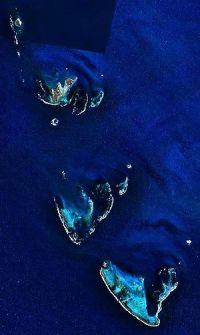
In just a couple of days I’ll join a group of scientists from Brazil, Australia and the US for an expedition to study the reefs of the Abrolhos platform, off Bahia state in Brazil.  When this trip was first mentioned I have to admit being confused.  That’s because, as a native Aussie, to me “the Abrolhos reefs” means a group of reefs and emergent islands off the remote Northwest coast of Western Australia.  So why are there two Abrolhos Reefs, and which came first?

My Brazilian friend and colleague Julia Todorov tells me that Abrolhos is a contraction of two Portuguese words, abro and olhos, meaning “open eyes” as in “Keep your eyes peeled, Marcos, lest you plough the ship into the reef!”.  That etymology is listed in several online sources.  The above Wikipedia link for the Aussie Abrolhos, however, says its not a true etymology, but I don’t see why not, since it applies just as well to reefs as it would to caltrops: basically, watch where you’re going!

Frederick de Houtman (Wikimedia commons)None of that explains why the Aussie reefs got the name, since the Portuguese did not explore Australia that we know of.  Nor does it explain which place name came first.  That’s a bit easier.  The Australian reefs are properly called the “Houtman Abrolhos” or “Frederick de Houtman’s Abrolhos” and were named by de Houtman, the captain of the Dutch East India Company ship Dordrecht in 1619.  He almost certainly named them after the Brazilian reefs, which he had previously sailed through in 1598.  The Brazilian reefs were already known and named at that time, so by name, the Brazilian Abrolhos came first.

Putting the trivialities of human history aside for a moment, we might ask a bigger question: which Abrolhos ultimately came first? Y’know, biologically.  Which reef grew up from the seafloor first?  In short, it was a tie.  Both reefs showed a major growth spurt around 8,000 years ago in the midst of the “last transgression”, when sea level started rising as the ice caps melted away from the last ice age.  This is a pretty common pattern everywhere.  In fact, there are pretty much no extant coral reefs anywhere older than about 12,000 years, since they were all high and dry back then (the reef organisms having receded into what are now much deeper areas).

OK then, if the current reef communities of the Abrolhoses (?) are both about the same age, then which reef came first geologically?  Which one has the longest geological history?  Chalk that one up as a win in the Houtman column.  The current  Houtman Abrolhos islands and reefs sit atop limestone bedrock that is the remnant of a coral reef that grew in the same location in the Quaternary period, before about 125,000 years ago.  The Brazilian Abrolhos, on the other hand, sit atop a layer of flood basalts (i.e. volcanic rocks, solidified lava) that spread out across the edge of the continental shelf during the Eocene (>30 million years ago).  When scientists core into the reef, the oldest reef they find before they hit the volcanic layer is a bit over 7,000 years; suggesting that the Brazilian reefs are relatively much younger (see Dillenburg & Hesp, 2009

The Houtman Abrolhos in Australia. (Wikimedia commons)Aside from the name and the similar recent growth spurt, the Abrolhos reefs have little in common; Houtman Abrolhos is a faily typical Indo-Pacific reef with high coral, invertebrate and fish diversity growing on a relict of an even older reef, whereas Brazilian Abrolhos is species poor and dominated by just a few coral and fish species growing on a volcanic base.  Could the short geological history of the Brazilian Abrolhos account for the biological differences?  Maybe, but biogeography probably has a lot to do with it too.  Houtman Abrolhos are not too far from the Indo-Pacific center of diversity, the highest tropical diversity there is and source of much species richness throughout the Indo-Pacific, whereas Brazilian Abrolhos are remote and cut-off from other major centers of reef diversity.  There will be a lot more to talk about regarding the diversity in Brazilian Abrolhos in future posts.

So the Aussie Abrolhos has probably been around quite a bit longer, but the Brazilian Abrolhos has been known to people (European at least) longer by about 100 years.  Despite this, the Brazilian reefs are still poorly known, having come to research and conservation attention only for the last two decades or so.  Its fantastic to think that on this expedition we will still have so much to learn about such a unique ecosystem.  I look forward to reporting  from onboard the R/V Seward Johnson some new biology in the Brazilian Abrolhos, starting later this week.  I hope you’ll stick around and join in the conversation.

Wednesday
Dec012010

A new angle on diving in whale sharks

ResearchBlogging.org

Recently I featured a piece about how turtle hatchlings change their movement strategy several times in just the first few hours of life in order to suit their changing needs as they move across different types of sand.  Well, to go from the sublime to the ridiculous (or rather, just from the really small to the truly gargantuan) there’s a new paper out that shows that whale sharks, too, adjust the way they move according to their needs.  This new work follows nicely after Phil Motta’s paper earlier this year, also discussed here, which took a comprehensive look at how whale sharks feed.  Between them they make big strides in the autecologyof whale sharks.  The new paper, by Adrian Gleiss and Rory Wilson from Swansea University and Brad Norman from ECOCEAN, describes work they did at Ningaloo reef in Western Australia, perhaps the world’s best studied aggregation area for whale sharks.  They took a new type of accelerometer tag developed in Rory’s lab called a “daily diary” and deployed them on wild whale sharks to measure not only where they are (like traditional wildlife satellite tags) but also details about what the animals were doing: the beating of their tails and the rientation of their bodies in 3 dimensions.  From this information they could basically reconstruct the animal’s actions with computer game-like accuracy (indeed, the software looks a lot like something for the X-Box!).  The findings show Whale shark with accelerometer tag. Photo: Steve Lindfieldan animal with a surprising diversity of movement modes and a sophisticated approach to minimising the amount of energy they spend moving through the ocean.  They also help explain one of the most enduring mysteries of whale shark biology - a curious pattern of super-deep dives over the abyssal depths.

The first big observation is that whale sharks have 4 different types of dives and that these probably serve different purposes.  It was well known from traditional tagging studies (sat tags record depth data as well as location) that whale sharks dive quite a lot throughout the day, but the new daily diary tags showed that not all dives are the same and, in fact, they could be easily discriminated as one of four main types based on what the depth profile looks like: yo-yo (probably searching), V (horizontal movement), U (feeding at depth), and bottom bouncing (searching at depth).

Four dive types in whale sharks. (a) yo-yo, (b) V-shaped, (c) bottom bounce, (d) U-shaped

The second and a really key finding is that all the dive types feature a gliding descent and an active ascent.  In other words, they don’t beat their tails on the way down, but they do on the way up. Gliding converts their negative buoyancy (a sort of potential energy) into horizontal and vertical movement (kinetic energy).  The fact that their dive has both vertical (depth) and horizontal (forward motion) components, without active use of the tail, shows that their bodies are adapted to convert sinking to swimming.  Most of that effect comes from their pectoral fins, which serve as wings for gliding, but there is probably a big contribution from that incredibly broad head, which serves as a sort of lifting canard, a flat plane that creates lift at the front end. Gliding is an extremely efficient way to move; not only are they not spending energy operating their musculature to beat the tail through the water to create thrust, but the drag coefficient of water across their skin is a third as much when they glide as when they are actively beating their tails.

The third finding, which Gleiss and friends really go into in some, ahem, depth, is that angle of descent and ascent is consistently different for each type of dive and that they are optimal for whatever the purpose is.  For example, a V dive is meant to cover a great horizontal distance, so the gliding descent is at a shallow angle and the ascent angle is the one that minimizes the amount of energy spent to gain horizontal distance. In contrast, the angles of a yo-yo dive minimize the amount of energy spent to gain vertical distance.  The important point is that for any given purpose there is an optimal angle - one that uses the least energy for the most benefit - for both descent and ascent components.  Whale sharks adapt the geometry of their dives to stay in that optimum zone and minimize the amount of energy they spend on whatever they are doing.  Clever right?  Well, its probably not a conscious decision, but rather a state of tremendous efficiency towards which they have evolved: natural selection is a powerful tutor.

Diving geomtry in whale sharks. The angles of descent and ascent (the two thetas) are optimised for minimum energy expenditureIn the course of their study, the researchers solved one of the great mysteries of whale shark biology: the extraordinary deep dives whale sharks do when they are over abyssal depths (see the Brunnschweiler reference).  These dives tend to happen around dawn and dusk and may exceed 1600m or more in depth; in fact, we don’t know just how far down they go, because most tags have a self-preservation device that cuts them free of the animal at 1600m, lest the tag be crushed by the immense pressure of the overlying water.  We’re talking depths enough to turn a Styrofoam coffee cup into a shrinky-dink thimble, as well as changing enzyme kinetics and making the urea in their blood greatly more toxic, so the motivation to dive so deep must be compelling. There had been suggestions that they go down to rid themselves of parasites (as a parasitologist, I never bought that: parasites would easily co-evolve to tolerate such a strategy), or to clean their filter plates (at those depths particulate organic matter redissolves!) or even to “sleep”, although there is no evidence that sharks do so.    Well, it turns out that they are dives of the V type, optimised to spend the least amount of energy while achieveing maximum horizontal movement (HD in the figure above).  In other words, to travel far, they glide deep, and then gently beat their tails and ascend at a very shallow angle (steeper angles costing more energy and achieving less horizontal distance).  This is a strategy best used during migratory phases when travelling, not feeding, is your number one priority. 

To recap then, whale sharks turn out to have at least 4 main types of dives, each serving a different purpose from feeding to horizontal travel, and the geometry of each type of dive is optimised to achieve the goal while minimising the energy cost.  Overall, it paints a picture of an animal that is a paragon of efficiency, which is understandable given that they dwell in the nutrient-poor surface waters of the tropics, which are typically much less productive than the rich cold temperate and Arctic seas frequented by their fellow filter feeders: basking sharks and baleen whales.  I suspect that future studies will show that whale sharks deploy these movement strategies to travel efficiently between hotspots of tropical productivity, be they fish spawning events or patches of seasonal tropical upwelling, and that they are therefore extremely strategic masters of the feeding/travelling trade-off.

Gleiss, A., Norman, B., & Wilson, R. (2010). Moved by that sinking feeling: variable diving geometry underlies movement strategies in whale sharks Functional EcologyDOI: 10.1111/j.1365-2435.2010.01801.x

Brunnschweiler, J., Baensch, H., Pierce, S., & Sims, D. (2009). Deep-diving behaviour of a whale shark during long-distance movement in the western Indian OceanJournal of Fish Biology, 74(3), 706-714 DOI: 10.1111/j.1095-8649.2008.02155.x

Monday
Nov012010

Seeing the world from a whale shark's point of view

My ECOCEAN colleague Brad Norman has been deploying Crittercam on some whale sharks in Exmouth, Western Australia.  I always wanted to try that; I’m so glad he did it!  The footage is now on National Geographic.  There’s a bit less actual Crittercam footage in the story than I would have liked, but thats just my own anxiousness to see what they see!  My guess is that a lot of it was much like the snippets shown - slowly cruising near the surface. 

I would LOVE to see what they see approaching food patches, or when they see another whale shark, or on one of their mysterious crepuscular dives (might need some supplemental lighting for that one).  Its a great start.

Thursday
Oct142010

Beautiful 3D map of the Great Barrier Reef

Led by geologist Robin Beaman, some of the clever folks at James Cook University in Townsville, in the northeastern Australian state of Queensland, have mapped in three dimensions and with unprecedented precision the seafloor off the Queensland coast.  In the process produced they’ve produced some spectacular imagery.

 Gorgeous isn’t it?  The map was made by melding together single beam and multi-beam sonar observations from ship-mounted equipment, with light detection and ranging (LIDAR) data, which are laser measurements taken from satellites.

Multi-beam sonar used to map the ocean floorBut it’s the scale thats really amazing here.  The path of the fly-through in that video is over 1,350 miles, or the distance from Miami to Provincetown (Cape Cod) or from the Straits of Gibraltar to the coast of Greece.  And they covered all the way from the Queensland coast to New Caledonia, encompassing an area of 6 million square kilometers, or about 2.3 million square miles.  Thats about the same area as the lower 48 states, except Texas, mapped - underwater mind you - to 100m resolution!  It was a mammoth job.  In the process they discovered some previously unknown features and, importantly, mapped the entire Great Barrier Reef, the worlds largest coral reef ecosystem.  These sorts of things will make the map an invaluable tool for folks at the Great Barrier Reef Marine Park Authority, who are charged with the management of this vast area.

You can read more about how they made their map here and a good story about the work in Australian Geographic here.

Sunday
May022010

A whaling conundrum

With tip of the cap to jfang at The Great Beyond

A recent proposal to limit whaling has been rejected by Japan and Australia, for opposite reasons. Japan, which takes almost a thousand whales a year, mostly Minke, objects to the 400 annual quota, which steps down after 5 years to 200 for another 5 years. Australia, which has a long history of opposing whaling, says the proposal doesn't go far enough; they're basically looking for a zero tolerance whaling policy.

Honestly, much as I hate the idea of even a single whale dying in the name of the imaginary research that Japan uses to defend commercial whaling, I think the Aussies might be being a little hard nosed in this case. Lets say the proposal is rejected, then the Japanese continue to take a thousand whales a year - how is that better? The art of negotiation is compromise, and in my view its always better to accept steps in the right direction, even if you don't get everything you want. Its like selling a car: you advertise for 10 grand, hope for 9, expect 8 and accept 7. If you hold out for 10, you're going to be disappointed most of the time.  Obstinacy doesn't help the cause.

In his vision for whaling, Peter Garret (Australia's environment minister) states that the right solution is to restructure the International Whaling Commission.  That may be so, but in the 2 years that it might take to do that, you could have saved 1,200 whales if you accept the current proposal first, and then go after the recalcitrant nations through a restructured IWC with more teeth.

There's a key line in the Great Beyond post linked above, from IWC chair Cristian Maquieira: “I don't think anybody will be happy with the numbers."  I often recognise that as the sign of a successful negotitation: a good outcome is not when everyone is happy, but when everyone is equally unhappy.

Tuesday
Apr272010

Me and Terry Hughes, we got Kwan

This is a little spooky. Terry Hughes of the Center for Excellence in Coral Reef Studies in Australia, whom I know only vaguely, has been quoted on the topic of the Shen Neng 1, that Chinese coal ship that ran aground on the Great Barrier Reef. His somewhat dismissive tone sounds creepily like my recent rant on the subject.

He said:
"The [Shen Neng 1] ship grounding, in the scheme of things, is not a major incident. It's bad if you happen to be one of the corals the ship parked itself on, but it's tiny in the face of the real problem: global warming."

I said:
"I am not worried in the slightest about this incident.  Not that its a good thing - far from it - but this accident is nothing more than a tree, obscuring us from seeing one big and scary forest [burning fossil fuels]."

Terry, you're my Ambassador of Kwan.

Thursday
Apr152010

Q: When is a ship like a tree?

A: When you can't see the forest for it.

You may have followed some press in the last week or so about a Chinese coal ship, Shen Neng 1, that ran aground on the Great Barrier Reef and spilled some of its fuel oil.  This has caused a regular frenzy in the Aussie media and the global conservation and environmental news-o-sphere.  There have been all sorts of calls for prosecution of the shipping company and new stringent regulations for the transport industry and so on, along with dramatic accounts of the damage the ship did and the risky salvage operation that came next.  But you know what?  I am not worried in the slightest about this incident.  Not that its a good thing - far from it - but this accident is nothing more than a tree, obscuring us from seeing one big and scary forest.

The main reasons I am not especially bothered by the Shen Neng accident are that (1) it affected a very limited area - the G.B.R. is really B.I.G. and one ship can only damage so much of it; and (2) it was a single event in time - this was not a process or an ongoing problem, but a singular disturbance.  Science shows us that the GBR, and reefs in general, are amazingly resilient to violent disturbances like this; a decent cyclone can literally turn a reef upside down, and a couple of years later you'd never know the difference.  Indeed, periodic disturbances may  be really important for maintaining a healthy reef ecosystem.

No, the Shen Neng is just a tree, obscuring us from seeing the forest that really threatens the future of the GBR and all reefs.  Its not the 2km gash that the hull cut in the reef, nor is it the tons of fuel oil leaked into the water; it's the very concept of burning that fuel oil, and burning the thousands of tons of coal that the Shen Neng 1 was carrying.  When you consider all the other ships and all the coal and fuel they were carrying that day and every day, and all the cars in the world, the power plants and so on ... ach, you get my point.  THAT'S what we ought to be worried about, because both of the main effects of increased atmospheric CO2 - warming and ocean acidification - will likely result in unrecoverable damage to All reefs. Everywhere. In our lifetime.  Warming is directly linked to lethal bleaching events, while acidification disrupts the ability of reefs to lay down their skeleton and grow.   Oh yeah, and lets not forget the drowning effects of sea level rise, too.  The more I think about it, the more it seems that jumping up and down about the Shen Neng is hypocritical (coal is one of Australia's biggest exports, after all) and akin to complaining about the deck chair arrangements of another, even bigger, ill-fated ship.  (Ironically, if Titanic sailed today, she probably wouldn't have to worry about icebergs...)

Of course, its a false dichotomy, we should be worried about BOTH the Shen Nengs of the world AND the global climate change/ocean acidification.  But I only have so much energy/capacity for worrying about these things, so with a limited anxiety budget, I feel compelled to focus on the bigger issue and what (if anything) we can do about it - to try to reduce consumption and to try to make sensible decisions that are mindful of how much energy is involved and what the broader impacts might be.

In other words, to worry about the forests - and let the trees take care of themselves.

Saturday
Apr102010

Field locations you have loved

In this thread I want to hear about field locations YOU have loved, and WHY.  Here's a couple of mine to get the ball rolling:

Kedron Brook, Brisbane, Australia.  A choked little stretch of suburban creek on the north east side of Brisbane Australia was a key field location for my PhD research, which was all about introduced (exotic) species and their parasites in rivers and streams in Australia.  At one point just above the tidal influence - stylishly named KB216 for its map reference - this creek is basically completely exotic: plants, invertebrates, fish, the whole shebang.  There aren't many parasites there, but those that were present were introduced hitchhikers.  Not sexy, but a veritable Shangri-La for a student on the hunt for ferals...
Heron Island, Queensland, Australia.  Where I met and fell in love with marine biology.  A patch of sand and guano-reeking Pisonia forest 800m long, on a reef 10 times that size, crawling with noddies, shearwaters, turtles, grad students and squinting daytrippers or more wealthy sunburned resort guests.  Too many firsts for me there to even list (but no, not that one - get your mind out of the gutter!).  Absolute heaven, hands-down.  How do I get back?

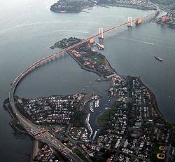
Throgs Neck, NY, USA.  You generally wouldn't think of the junction of Queens and the Bronx as a biologically interesting in any way (except maybe on the subway), but actually the western part of Long Island Sound was the epicenter of a lobster holocaust that started in (well, before, if you ask me) 1999.  When we were out on the RV Seawolf, the Throgs Neck bridge marked your entry into the East River and the start of one of the most unique and strangely beautiful urban research cruises around, right down the East side of Manhattan, past the Statue of Liberty and out into the Lower NY bays.  We would pass through on our way to do winter flounder spawning surveys off the beach at Coney Island (its that or go around Montauk).  Proof that not all interesting biology takes place in Peruvian rainforests...

In the comments, tell us about a field location YOU have loved and why.  Post links if you can find them.

Friday
Mar262010

Lionfish - more spectacular than your average invasive, but still a right pest.

When we think of invasive species, flamboyant fish from coral reefs are not usually the first thing that comes to mind.  Indeed, if you put together a list of characteristics of successful invasive species (like this one), "boring" would probably be close to the top, along with being quick to reproduce, not fussy about what you eat, having a large natural range, a great tolerance for extremes in the environment, and lacking natural enemies such as predators or parasites.  Think of some of the most successful invaders and decide for yourself if these predictions hold true: carp, starlings, mosquitofish, rats, sparrows, mice, rabbits, dogs, cane toads, cats, foxes, kudzu, chickweed... 

All this makes the invasion of the Atlantic seaboard by the Pacific lionfish, Pterois volitans, all the more remarkable.  Lionfish are flat-out spectacular!  Long prized as an aquarium specimen, they have bold stripes that spill over onto their fantastically long and showy fins; their scientific name even means "fluttering wings".  The sheer beauty of lionfish doubtless plays a role in how they came to invade the Atlantic in the first place; most likely they were an escaped or released aquarium species that found itself able to survive quite nicely in the conditions of the coastal Atlantic.  The beauty of lionfish conceals a dangerous secret - venomous spines on their dorsal (back) and pelvic (bottom) fins.  While they won't kill a person; they cause excruciating pain.  I've never been stung by one, but I have been stung by related scorpionfish (most recently the short-spined wasp fish) and the feeling is not one I'd care to go through again!

Over the course of just a few years, mostly since 2000, lionfish have spread dramatically along the coast of the Atlantic, from North Carolina down to the southern Caribbean and Mexico's beautiful Yucatan peninsula.  Typically considered to be a rocky or coral reef species, they've now been found swimming in the intracoastal waterway; that labyrinth of salt-marshes, channels and estuaries, engineered to allow safe passage of boats along the US coast in wartime.  This is sort of an unusual location, but it speaks to the adaptability of this remarkable fish.

So, what to do about such an animal??  Well, that's a tough one.  Invasive species (or more accurately, moving species around) are one of the greatest impacts humanity has had on natural environments, and there are very few cases where we have successfully eradicated or controlled an invasive (but see prickly pear in Australia), more often they just become part of the furniture and we get used to their impacts on the local ecosystem.  Introducing natural enemies (diseases, predators) like they did for prickly pear is a dangerous game; if you tried to get the Cactoblastus moth introduced to Australia in these days of stricter biosecurity, you'd almost certainly be denied.  You can easily get into a "spider to catch the fly" situation too; in fact that's how cane toads were introduced to many places - to control sugar cane beetles (which they suck at).  Perhaps the best approach is to do what we do best - create a market that will promote human efforts to exploit them, and then rely on the Tragedy of the Commons to do the work for you.  This has already been proposed with Asian carp.  Fortunately, it turns out that lionfish are not only spectacular aquarium fish, but also delicious in a white wine sauce.  I am sure that if we set our minds to it, we could do as good a job wiping out this species as we have with so many others.  So c'mon everyone and grab a fork; Save a reef - eat a lionfish, today!

(Photo and graphic from NOAA)

Friday
Mar192010

Ului inches closer

Looks like Ului will cross the coast right over the Whitsunday Islands.  Good luck to the folks in Proserpine and Bowen.

This picture from the Australian Bureau of Meteorology