Networked Blogs
Search this site
Twitter and News feeds
Navigation
Sunday
Jan232011

Rocking the Abrolhos

This is the first post from onboard the R/V Seward Johnson, currently at 18 deg 6 min S, 38 deg 25 min W, somewhere off the coast of Bahia State, Brazil.

_______________________

Alex Bastos likes rocks.  Biologists may scoff, but the truth is that rocks and geology provide the context for biology in the oceans, much the same way as a playing field provides the context for a game of football.  In an expedition concerned with coral reef ecology, then, it’s important to have a thorough understanding of geological processes, because they shape the history of the reef and can help predict its future.  Dr. Bastos, who hails from the Federal University of Espirito Santo, is a marine geologist with a special interest in the Abrolhos.  He is trying to understand what has happened in the prehistoric past and what is happening on the reef today by reading the shape of the bottom features (what geologists like to call morphology) and reconstructing a story and past and present events on the Abrolhos shelf.  Scientists call this sort of activity “inferring process from pattern”, and in terms of marine geology it brings with it some special challenges.  The biggest of these is that, for the most part, Alex can’t see the morphology he wants to study, certainly not as easily as a terrestrial geologist might fly above a mountain range and read the faults and synclines of the landscape to understand what geological forces shaped the land.  No, he has to construct his story a piece or two at a time, like putting together a jigsaw puzzle, often from indirect evidence.  He gets his jigsaw pieces from some pretty cool technology though, including seismic equipment, side scan sonar and by drilling cores out of the sediment.

Side scan sonar is an especially great tool that has become really popular in research circles in recent years.  It uses sound to reconstruct bottom morphology by sending out high frequency noises and then gathering back the echoes off the bottom, much the same way bats find food.  What makes side scan different from regular sonar is that instead of aiming the sound straight down under the boat, it is directed away to each side.  Since the sound hits objects and bounces back at an angle, any structure of any height will cast a sort of sound “shadow” on the side facing away from the boat.  The resulting image is a plan view, but with shadows that reveal shapes and structures, rather like taking a photo from an aeroplane late in the day, when shadows are long on the ground.
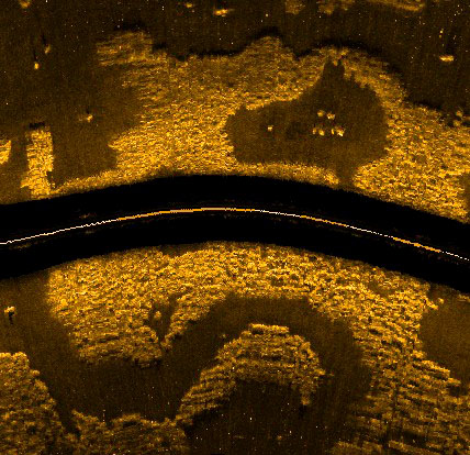
Side-scan reveals and ancient river channel. Img: Alex BastosBy combining studies of morphology with reconstructions of sea level at different times in geological history, Alex tells a story about the way the Abrolhos platform evolved.  Around 40 million years ago the main playing field was established by a flood of volcanic basalt that spread out to create the basis of the platform.  In the ensuing geological periods, carbonate rocks (i.e. limestone) were deposited, implying that reefs existed there at times in the distant past (my assertion in a previous post that there were no reefs on Abrolhos before 8,000 years ago was wrong).  During the last ice age, the sea level was over 100m lower than its current height, so much of the platform, including the locations of all the current shallow coral reefs, was above the surface.  At that time, a central depression in the platform was probably still filled with water, forming a shallow coastal lagoon opening to the south.  The Caravelas River probably drained into this lagoon from the north, cutting a number of different channels through the limestone as it meandered over time.  The river also provided a source of sediment that fanned out off the edge of the platform from the mouth of the lagoon.  All three of these features – the shallow depression, the channels in the limestone and the sediment fan – are still there on the bottom of the sea and help to tell the story.  At the end of the last ice age came the last great transgression, when sea level rose to approximately its current levels.  The entire platform was flooded, and corals once again colonized the platform and began to grow up towards the surface to where we see them today.
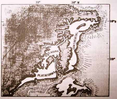
How Abrolhos might have looked during the last ice age; note the central lagoon opening to the south
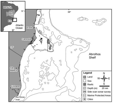
Current bottom topography of Abrolhos; note central depression due south of the islands

Holocene sedimentary processes.

Unfortunately, morphology only gets you so far.  Knowing the history of the platform, many of Dr. Bastos’ questions now relate to what has happened since the last transgression, during the most recent geological period (the Holocene), and most of these need other methods to answer.  These questions include “Is all the sediment on the platform a relict of geological history, or are sediments actively being deposited to this day?” and “If they are still being deposited, do they come from the land via the river, or are they produced in the ocean by corals, coralline algae and other organisms?”  To answer these questions, Alex will use a combination of seismic methods and sediment cores.  Seismic surveys provide indirect evidence of the nature of sediments below the surface of the sea bed, and these can be calibrated or “ground-truthed” by taking sediment cores that will reveal a timeline of sediment history on the platform.  These geological questions played a large part in the choice of sites for the main transects on this expedition.  One is to the south, in the mouth of that ice-aged lagoon, on the edge of the shallow-sloping fan of sediment.  The other is in the north, on a much steeper shelf break where the platform gives way to the deep sea beyond.  These two locations not only have profoundly different geology, but it’s likely that organic processes differ between them too, as we shall see in a future post.

Applying the lessons

Alex was telling me that one of the more satisfying aspects of his work is translating geology data into benthic (bottom) habitat maps.  In other words, taking all that information from the sonar morphology, the seismic data and the sediment cores, and mapping out what different parts of the platform are like on the bottom.  This is important, because once scientists can say with confidence that Area X is a rhodolith bed, or Area Y is a steep-sided valley, then they can predict with good accuracy what sorts of organisms will live there.  That sort of information is of critical value when deciding where to take biological samples and even more so when the Ministry of the Environment needs to make decisions about the boundaries of protected areas, which they are currently doing.  In this way geology plays a very important role in both the biological sciences and in conservation decision making.

Saturday
Jan222011

Welcome aboard!

Friday
Jan212011

Getting down to the nitty gritty

How deep can we go?  How can we collect fish?  How much water can we sample at once?  These are just some of the questions that filled today’s planning session in Vitoria for the Abrolhos 2011 expedition.  They’re not straightforward questions to which some resident authority has a simple answer.  No, when you’re planning work between 300 and 3000 feet down, no questions are simple, and nor are the answers easy; rather, they are crafted through a careful group discussion of what’s a priority, what’s possible, what’s practical, and what we have time for.  In other words, its not all The Life Aquatic, its large parts careful planning and preparation.

The day started with presentations from representatives of Cepemar, Harbor Branch and the Rosenstiel School of Marine Science at U. Miami.  After that, Rodrigo Mouraled the planning session where we talked reef biology for hours, fueled (as all the best science chats are!) by shots of excellent Brazilian coffee.  Dr. Moura is a faculty member at Santa Cruz University and a consulting scientist with Conservation International, who have a substantial marine conservation program focused at Abrolhos.  He explained all the things that make Abrolhos unique, from the 40,000km2 platform on which they occur, to the unique fauna and dominance of shallower reefs by the endemic coral Mussismilia braziliensis, to the unusual mushroom formation of these reefs (chapeiroes), and finally to the history of human impacts and conservation efforts surrounding these unique ecosystems and the deeper and less-known seafloor habitats around them.  The Abrolhos Marine National Park was the first marine national park in Brazil, established in 1983, but like many reefs it faces its fair share of threats from pollution, global climate change and marine development.

 Suitably up to speed on the history and context for the expedition, the next speakers were the 8 principal investigators to give details of the motivations for their respective parts of the expedition, and to outline their specific sampling needs.  Alex Bastos, a geologist from the Federal University of Espirito Santo, talked about the geological history of the platform, how its central depression was likely once a shallow coastal lagoon during the last ice age, and how taking samples of sediment from the bottom will explain more about how the reef came to be and how much it contributes to calcium carbonate production in that part of the Atlantic. Paulo Sumida from the University of São Paulo explained how organic matter (carbon based material either secreted from living organisms or leftover by dead ones) is distributed unevenly across the platform, with more in the south and less in the north.  We learned from Mauricio Torronteguy’sgroup at Cepemar how water sampling and measurements of the properties of the water overlying the reef would be used to provide a better understanding of the biology taking place on the reef.  Microbiologist and geneticist Fabiano Thompson from the Federal University of Rio de Janeiro explained what has been learned about the importance of Vibriobacteria on the reef, both as potential agents of disease in corals and, surprisingly, as possible agents of photosynthesis; i.e. food production from sunlight.  Vibrios were not previously known to use light for food, so this is potentially big news.  His graduate student, Nelson Alves, will be sampling for water-borne viruses by looking for their DNA signature.  These aren’t viruses as we know them (causes of A rhodolith bedhuman disease), but a natural and dominant part of the very smallest members of the plankton, whose importance has only been realized in the last few years.  Gilberto Filho, who is a head botanist at the Botannic Gardens in Rio de Janeiro, talked about the importance of rhodolith beds, which are an unusual sort of habitat made up of softball-sized lumps of reddish rock that are produced by algae that are able to secrete calcium skeletons as they photosynthesise, much like corals do.  These lumps then become substrate for all manner of other things to live on, since they are hard and rigid, unlike the soft, shifting sediments on which they sit.  In this way, rhodoliths can increase the diversity of a patch of otherwise empty seabed.  Ronaldo Francini-Filho talked about what is known and not known about some of the bigger critters that make up the reef community, like fish and larger invertebrates.  The final presentations from National Museum scientist Clovis Castro and student Gustavo concerned deep-sea corals of the Abrolhos, including those that use light and have symbiotic algae in their tissues (zooxanthellate) and those that lack algae and feed by filtering plankton or absorbing organic material directly from seawater (azooxanthellate).  We’ll learn more about each of these projects in coming days, so if you have questions for the researchers, by all means post them in the comments below. 

The hardest part of planning a research trip came next: deciding how on earth we’re going to meet everyone’s needs within a limited timespan, using the assets of the ship and the brain trust of people aboard it.  This is where the beautiful ideality of a proposed sampling scheme meets the stark and sometimes gruesome reality of what you can, practically speaking, actually do.  All scientists, especially biologists, know and dread this bit; indeed, Mmmmm…mesophotic reefs…argleargle….a lot of the very best biologists are those that have mastered this challenging process and can come up with intelligent and efficient sampling schemes that provide maximum bang for the research buck and minimize down or wasted time.  The upside of this process is that as everyone thinks and talks, you start to see the days to come materializing before you, and a sense of very real excitement sets in.  Ahead lie mornings spent deploying the submersible, afternoons sorting samples of sediment, deep sea corals and sponges, and evenings spent measuring water column properties with a CTD/Rosette and ADCP (more on these later).  It’s enough to make any marine scientist practically drool with anticipation. 

Friday
Jan212011

U.S. and Brazilian researchers

Scientists from Harbor Branch and Brazilian universities in Vitoria Skype with operations staff aboard the RV Seward Johnson off the coast of Bahia, to plan submersible activitiesas part of the Abrolhos 2011 expedition.

Thursday
Jan202011

The start of something beautiful

My travelling partner Kristie Cobb (Georgia AquariumVP) and I arrived in Brazil today for the Abrolhos 2011 expedition.  The flight in from Atlanta is long (10hrs) and a red-eye, so we arrived a little the worse for wear in Rio.  As we flew, I was considering the similarities and differences between Brazil and Australia.  Brazil’s great mountain range is to the west and is immense in both length and height: the Andes.  It circumscribes the Amazon basin, the most spectacular crucible of biodiversity on the planet.  It drains to the eastern seaboard, which has some coral reefs (including the ones we’ll survey), but nothing like the Great Barrier Reef.  By contrast, Australia is mostly a giant flat arid zone (Google the awesomely ominous sounding “yilgarn kraton” to learn more) with its “great” mountain range on the eastern coast, where a once-active subduction zone scraped off enough Pacific sea floor to make a strip of lan on which >75% of Aussies live.  I say “great” because even the highest of the Snowy Mountains is a pimple compared to the Andes.  There are rainforests in appropriate microclimate pockets along the great dividing range, sure, but not like the vast unending ones we flew over today; there just isn’t the volume of reliable rain (recent floods notwithstanding).  Partly as a result of that tiny eastward drainage and low rainfall, the tropical coastal waters of north eastern Australia are nutrient poor and therefore ideal for coral reefs; accordingly, the Great Barrier Reef is the Amazon rainforest of reefs.  They are two countries with priceless biodiversity treasures, of totally different kinds, as dictated by the constraints of their respective geological histories and their prevailing climates.

We came within three miles of the mighty Amazon today; it was just a pity that it was a vertical three miles!

During an awkwardly long layover in Rio de Janeiro, we decided to bail on the airport and make a lightning visit to the famous Christ the Redeemerstatue; a gargantuan art deco edifice that presides over the spectacular sprawl of beachfront hi-rises and mountain-clinging favelasbelow.  I’m really glad we did too, because the views were stunning and the statue itself a marvel; I’m not a religious guy, but you have to admire the inspiration that drives people to conceive of and build such things on that tiny inhospitable peak at the top of Corcovado.

Christ the Redeemer statue, Rio de Janeiro

After that we made our connection to Vitoria, in the state of Espiritu Santu, north of Rio.  Here we will meet up with our Harbor Branch and Brazilian colleagues for a research co-ordination meeting tomorrow; then a short charter flight to meet the R/V Seward Johnsonat our port of departure in Bahia state.  Right now though, it’s caipirinha o’clock!

Tuesday
Jan182011

Grasping the scale of the Queensland floods

Sam at Oceanographers Choice has an excellent post up that seeks to address a journalist’s statement that Queensland (Australia) “should have seen the flood coming”, using a quick climatology exercise relating rainfall and the climate pattern called El Nino Southern Oscillation (currently in a strong La Nina phase) in that part of the world.  In short, the answer is probably not, no; ENSO is an OK predictor at annual scales, but probably not usefully predictive at the monthly scale that would be needed to prepare a response to an anticipated flood event.

Seasonal rain cycles in Queensland, Australia

My friends in Brisbane (where I lived for 8 years during college) have all been affected directly by the flood or know someone who is.  One friend rescued neighbours in a boat and another is still missing a friend in Toowoomba, west of Brisbane.  The floods are getting a bit of press in the US, but perhaps not as much as they should because the body count is low (~25 compared to >600 in the concurrent Brazilian floods).  That’s mostly a function of Queensland’s low population, so don’t be fooled; we’re still talking about a once-a-century or worse flood event.  75% of the state is affected, which might not sound like much until you realise that Queensland is three times the size of Texas at over 715,000 sq. miles!  It is a truly gargantuan issue, especially now that there is also some flooding in Victoria and other southeasterm states.  This is the equivalent of a flood that extends from Cape Hatteras to Miami and Savannah to Houston!  Total cost is expected to be on the order of $10 billion, which in a state of 4.5 million is over $2,000 per person.  Its staggering.

Australia truly is a land of droughts and flooding rains.


Tuesday
Jan182011

Tis the season of sailfish!

This time of year sailfish gather to feed off the coast of the Yucatan Peninsula in Mexico.  One day I’ll go and see it in person, but in the meantime, David Attenborough will have to do:

Monday
Jan172011

Which came first, the Abrolhos or the Abrolhos?

In just a couple of days I’ll join a group of scientists from Brazil, Australia and the US for an expedition to study the reefs of the Abrolhos platform, off Bahia state in Brazil.  When this trip was first mentioned I have to admit being confused.  That’s because, as a native Aussie, to me “the Abrolhos reefs” means a group of reefs and emergent islands off the remote Northwest coast of Western Australia.  So why are there two Abrolhos Reefs, and which came first?

My Brazilian friend and colleague Julia Todorov tells me that Abrolhos is a contraction of two Portuguese words, abro and olhos, meaning “open eyes” as in “Keep your eyes peeled, Marcos, lest you plough the ship into the reef!”.  That etymology is listed in several online sources.  The above Wikipedia link for the Aussie Abrolhos, however, says its not a true etymology, but I don’t see why not, since it applies just as well to reefs as it would to caltrops: basically, watch where you’re going!

Frederick de Houtman (Wikimedia commons)None of that explains why the Aussie reefs got the name, since the Portuguese did not explore Australia that we know of.  Nor does it explain which place name came first.  That’s a bit easier.  The Australian reefs are properly called the “Houtman Abrolhos” or “Frederick de Houtman’s Abrolhos” and were named by de Houtman, the captain of the Dutch East India Company ship Dordrecht in 1619.  He almost certainly named them after the Brazilian reefs, which he had previously sailed through in 1598.  The Brazilian reefs were already known and named at that time, so by name, the Brazilian Abrolhos came first.

Putting the trivialities of human history aside for a moment, we might ask a bigger question: which Abrolhos ultimately came first? Y’know, biologically.  Which reef grew up from the seafloor first?  In short, it was a tie.  Both reefs showed a major growth spurt around 8,000 years ago in the midst of the “last transgression”, when sea level started rising as the ice caps melted away from the last ice age.  This is a pretty common pattern everywhere.  In fact, there are pretty much no extant coral reefs anywhere older than about 12,000 years, since they were all high and dry back then (the reef organisms having receded into what are now much deeper areas).

OK then, if the current reef communities of the Abrolhoses (?) are both about the same age, then which reef came first geologically?  Which one has the longest geological history?  Chalk that one up as a win in the Houtman column.  The current  Houtman Abrolhos islands and reefs sit atop limestone bedrock that is the remnant of a coral reef that grew in the same location in the Quaternary period, before about 125,000 years ago.  The Brazilian Abrolhos, on the other hand, sit atop a layer of flood basalts (i.e. volcanic rocks, solidified lava) that spread out across the edge of the continental shelf during the Eocene (>30 million years ago).  When scientists core into the reef, the oldest reef they find before they hit the volcanic layer is a bit over 7,000 years; suggesting that the Brazilian reefs are relatively much younger (see Dillenburg & Hesp, 2009

The Houtman Abrolhos in Australia. (Wikimedia commons)Aside from the name and the similar recent growth spurt, the Abrolhos reefs have little in common; Houtman Abrolhos is a faily typical Indo-Pacific reef with high coral, invertebrate and fish diversity growing on a relict of an even older reef, whereas Brazilian Abrolhos is species poor and dominated by just a few coral and fish species growing on a volcanic base.  Could the short geological history of the Brazilian Abrolhos account for the biological differences?  Maybe, but biogeography probably has a lot to do with it too.  Houtman Abrolhos are not too far from the Indo-Pacific center of diversity, the highest tropical diversity there is and source of much species richness throughout the Indo-Pacific, whereas Brazilian Abrolhos are remote and cut-off from other major centers of reef diversity.  There will be a lot more to talk about regarding the diversity in Brazilian Abrolhos in future posts.

So the Aussie Abrolhos has probably been around quite a bit longer, but the Brazilian Abrolhos has been known to people (European at least) longer by about 100 years.  Despite this, the Brazilian reefs are still poorly known, having come to research and conservation attention only for the last two decades or so.  Its fantastic to think that on this expedition we will still have so much to learn about such a unique ecosystem.  I look forward to reporting  from onboard the R/V Seward Johnson some new biology in the Brazilian Abrolhos, starting later this week.  I hope you’ll stick around and join in the conversation.

Friday
Jan142011

Open Lab 2010

Jason Goldman at the Thoughtful Animal is the editor of the 2010 Open Lab anthology, a compilation of the best scientific blog posts for the year, as judged by a group of volunteer science blog editors.  Interestingly, the Open Lab anthology is printed as an actual paper book (remember them?) to serve as a lasting record of science writing from blog-land, so keep an eye out here for links to the final printed product, when it emerges.  In the meantime, I’m thrilled to be one of the 60 chosen from 900 submissions for Dancing With a Giant, a piece written while on field work in Mexico for Georgia Aquarium , after an especially profound encounter with a whale shark.  Thanks to the editors and congrats to the other bloggers chosen for the 2010 Collection!

Thursday
Jan132011

Abrolhos, here we come!

Mussismilia braziliensis at the Abrolhos Reefs, BrazilThings have been a little quiet around here over the holiday break, but that’s about to change in a big way.  In just under a week’s time, I’ll be representing Georgia Aquarium in a new international consortium of scientists for an exciting expedition to explore the Abrolhos reef platform off the coast of Brazil from January 20-28.  The Abrolhos are completely unique reefs: they’re the largest and southernmost in the South Atlantic and biologically very different from perhaps more familiar Pacific or Caribbean Reefs.  You’d think they might show some similarity to Caribbean reefs, but not so, possibly because unfavourable currents and the influence of the Amazon pouring into the ocean between the two may serve as an important barrier to animal dispersal (more on that in future posts).  There’s tremendously high endemicity there, which is to say that many of the resident critters are found nowhere else in the world.  Of key importance is the main reef-forming coral Mussismilia braziliensis, a massive species that forms an unusual bommie-like reef structure called a mushroom reef; we’ll meet this species in more detail later too.

The main aim of the expedition is actually to go a bit deeper than the known parts of the Abrolhos, and look at the depths where light starts to get dim: the mesophotic zone.  These parts of many reef platforms are poorly known and nowhere moreso than at Abrolhos, where these areas are completely unexplored.  That’s because mesophotic reefs are beyond comfortable SCUBA diving range and therefore hard to get to.   To study them between 300 and 3,000ft in depth, we’ll be using the Johnson Sea Link, a submersible that operates from the R/V Seward Johnson, which is on a 5 year assignment from it’s home at Harbor Branch Oceanographic Insitute to CEPEMAR, a Brazilian environmental services company.

The Johnson Sea Link and R/V Seward Johnson

There’s much more to come in future blog posts here and in my tweet stream @para_sight or using the hashtag #Abrolhos2011.  We’ll discuss the Abrolhos reefs, mesophotic reefs, some geology and biology, as well as meeting the people and partners and exploring the logistic challenges of making a complex expedition like this happen.  So, I encourage you to follow along and also to share this information with colleagues and (especially) students of marine science so that they might also follow and share in the excitement of discovering new parts of the ocean floor, never seen before, in tropical Brazil.

Tuesday
Jan042011

A DonorsChoose update

In the fall, the readers of this and other marine science blogs supported a combined “Ocean Bloggers United for Education” campaign to raise money for improving K-12 marine science education in underprivileged schools.  I just wanted to update you on one of the pet projects of this blog: the Mirror Universe project at a Paulding County middle school here in Georgia.  We reached their funding goal and the class was able to purchase the necessary materials to study underwater topography and the forces that shape it.  Mrs L., the class teacher, writes:

“Thank you for your incredible generosity. My school is facing budget cuts and without your donation my students would not have been able to use these amazing supplies. My students have had a great time using the rock samples, globe, aquarium and seafloor model.  We used the aquarium and seafloor model to learn vocabulary and create topographic maps. Students are always surprised to discover that there are mountains, canyons, and volcanoes below the ocean’s surface. When we used the globe to locate the features they were able to understand that the geographic features on the land and under the water are very similar. This year my students were able to see and touch the features on the ocean floor. I feel like the aquarium, seafloor model and globe really helped my students understand this unit.  I can’t wait to use the aquarium to teach my students about currents and seafloor resources. I know that seeing the currents in action is going to help my students understand more about the ocean.”

Some of the kids will also be coming to the Aquarium for a visit later in February.  I’ll be sure to post pics and stories from that visit when they come.  My thanks again to the kind readers who joined the marine science bloggers in donating to improve science education. Truth will out!

Tuesday
Dec282010

Five of the biggest marine science stories in 2010

Yes, I caved to the impulse and joined the inevitable cavalcade of “lists” that come at the end of every year.  Why?  Because these lists actually serve an important purpose: they cement the events of the past 12 months in our psyche and provide context about where these events fit into the grand passage of time.  They also give us something to read when we want to procrastinate shoveling snow off the driveway or vacuuming pine needles from behind the couch.  So here they are: five of the biggest marine science news stories from 2010.

5. National Ocean Policy.  Starting off sexy, right? Policy, yeeeahh baby!  No really, it IS a big news story that in July of this year the Whitehouse announced that the US finally has a comprehensive Ocean Policy.  That’s because such a document - and the institutions it enhrines - recognises the critical role that the oceans play in the lives of every American, even those that live far removed from the coasts.  As the biggest per capita consumers (and polluters) on the planet, the absence of a national policy to protect the oceans had long been lamented by marine scientists and consrvationists alike.  Now we have a National Oceans Council and a set of guiding principles for governing the use (and abuse) of coastal oceanic resources.  Its about time!  Read the Executive order here, and the Final Recomendations of the Ocean Policy Task Force here

4. What a load of garbage.  2010 marked the year that the concept of the “great ocean garbage patches” entered the public consciousness.  If you’ve been living under a rock and have no idea what that is, well, it’s the idea that millions of tons of plastic pollution have found their way down urban drains, to creeks, rivers and estuaries and thence to the centers of the great circular oceanic currents called gyres.  There becalmed, these floating fields of plastic debris form giant rafts of death, entering food webs and silently choking millions of animals.  The truth is slightly less dramatic; while the grabage patches are almost mind bogglingly large, the density of plastic particles within the patches is actually pretty dilute.  In fact, you have to sift a lot of water to recover appreciable quantities of the stuff; it’s just that, even then, they have vastly higher concentrations than parts of the ocean more well-mixed by large scale currents.  2010 was the year that scientists recognised that there is not only one patch (in the north Pacific) but probably a patch of sorts in the center of every gyre and that therefore this is a global problem.  Its also the year that the concept hit pop culture, partly from the well-publicised efforts of the Plastiki cruise, but mostly in the form of a new album from progressive UK hip hop outfit Gorillaz called “Plastic Beach”, a theme album conceived when the lead singer was sitting on a beach and realising how much of the sand was actully composed of tiny bits of plastic.  The garbage patch story also added the most excellent word “nurdle” to the lexicon, reason enough for it to appear on this list.  Read more about the adventures of a bona fide garbage patch researcher by following Miriam Goldstein at DeepSeaNews

3. To hack, or not to hack?  It’s pathetic, but perhaps not surprising, that the worlds leaders have not been able to agree on a binding plan of action to reduce carbon pollution and its two biggest impacts on the planet: global warming (both the atmosphere and the oceans) and ocean acidification.  First at the COP15 Copenhagen conference in late 2009 and, more recently, at the 2010 United Nations Climate Change Conference in Cancun, Mexico in December, politics consistently trumped the urgent need to reconstruct our industries and economies to prevent exacerbation of the problem (we’re already committed to a certain level of globe-changing temperature and pH shift).  While these “front end” solutions are desperately needed, a number of climate/ocean researchers around the world have been studying “back end” solution, the most familiar of which is carbon sequestration - the idea of catching CO2 from fossil fuel burning and burying it or otherwise preventing it from entering the atmosphere/ocean.  Perhaps the most controversial suggestion is to fertilise the oceans with nutrients that usually limit the growth of plankton (Iron is the best-studied), thereby causing huge plankton blooms that suck CO2 out of the air/water and, ultimately, export it to the bottom of the abyssal oceans.  The controversy of these sorts of planet-level solutions, collectively called “geo-hacking”, arise because they are designed to affect the whole earth ocean/climate system and take place in international waters, so arguments arise about who gets to decide on these sorts of things.  No sooner had I interviewed an expert on ocean fertilisation on this very blog than a UN moratorium was issued preventing any future research on this kind of solution until the risks and impacts are better understood.  C’mon UN - you can’t have it both ways: either make an internationally-binding decision about reducing carbon pollution, or allow people to move forward with alternative solutions, preferably both.  As it stand currently, we’re a boxer with both arms tied behind his back, and that’s never good.

2. BP/Macondo/Deepwater Horizon Oil Spill.  Bet you thought that would be number 1 right?  By volume, the largest oil spill in US history, affecting huge areas of the Gulf of Mexico in the peak of seafood season and threatening hundreds of miles of fragile coastal wetlands, surely it should be.  Nope.  Why not?  Well, largely because - disastrous though it was/is - it is both temporally and geographically restricted in its impact.  In other words, its effects will be found primarily in one place and for a limited (albeit relatively prolonged) time.  I argue that it is NOT these events that we (the world) need to be concerned about, but the long-term, chronic, death-by-a-thousand-cuts kind of problems.  The biggest of those are global warming and ocean acidification (see number 3).  It’s like the difference between a big financial windfall and the power of investment returns.  The local factory worker who wins a hundred million on the latest Powerball gets the news story, while tons of investors accumulate vast wealth in relative silence due to the inexorable influence of compounding interest and capital gains over time.  The BP spill was an absolute disaster that got a LOT of press and will keep many marine scientists and environmentalists busy for a long time (great coverage of both is at DeepSeaNews), but it’s a one-off event and not even on the radar in terms of the global health of the oceans.

1. Census of Marine Life.  The biggest marine science news of 2010 has to be the completion of the first Census of Marine Life; a phenomenal decade-long effort by thousands of marine biologists around the world to answer one simple question: What lived, lives and will live in the worlds oceans?  The brainchild of Rutgers marine scientist Fred Grassle, the scope was truly gargantuan: over 500 research expeditions covering every ocean, over 2,500 scientists and the discovery of over 6,000 species new to science and published in over 2600 peer-reviewed papers.  It revealed the chronic undersampling of the deep-pelagic realm and the incredible diversity of seamounts and the tropical, arctic and antarctic depths.  It also brought us some of the most stunning and engaging images of marine diversity ever captured.  The final estimate? Based on extrapolations of survey data, easily 1 million or more eukaryote species and perhaps as many as 10 million bacteria and archaea.  But CoML is so much more than numbers, it’s a peek into a treasure trove of new life, a testament to the phenomenal diversity of the oceans, and an enduring snapshot of the precious biological legacy we are lucky to be part of.  It’s often said that you don’t know what you’ve got til it’s gone.  Well, thanks to CoML we have a better idea of what a priceless gift of diversity we’ve got at our fingertips.  Now what are we going to do about it?

I’d love to read your feedback in the comments.  Did I miss anything?

Tuesday
Dec212010

Chalk up a win for shark conservation

Yesterday the US senate finally passed the Shark Conservation Act that had passed the House of Representatives back in March 2009.  After an approval vote in the House, it can be signed into law, probably during this session.  David at Southern Fried Science has an interesting post about whether this is *entirely* a win for sharks, since it still contains language that would allow limited finning of smooth dogfish (but see my comment on his thread).  On balance, though, any legislation that brings wider attention and some better legislative regulation to shark fisheries is a move in the right direction.  Perhaps one day we’ll see a blanket ban on finning, but in the meantime I’m happy to call this one a pretty big win.

Tuesday
Dec212010

Sharky Christmas swag

David Shiffman at Southern Fried Science passed along this opportunity to get some sharky swag for your loved ones and help the American Elasmobranch Society student arm as well.  SO, go get some, and feel good that your purchase is helping students of shark science!

___________________________________________________

Are you looking for a great source of shark-themed gifts for yourself or the shark nut or SCUBA Diver in your life? Are you looking for an easy way to help sharks and support science? Check out the American Elasmobranch Society’s Student Store!

The American Elasmobranch Society (www.elasmo.org) is the primary scientific society of shark researchers, and they take pride in making sure that deserving student shark researchers can afford to travel to the AES Conference each year. Though they budget funds towards this, students like to do our best to help by running the AES Student Store.

You can find all sorts of good stuff, from shark shaped bottle openers to shark-covered Hawaiian shirts and everything in between. New items this year include shark fin shaped ice cube trays, cookie cutters, aluminum water bottles, and blown glass Christmas Tree Ornaments. Check it out, and know that you are helping a good cause as your shop!

If you order by Tuesday morning, items should arrive in time for Christmas.

Older items can be found here:
http://www.elasmo.org/market.php

And here:
http://www.cafepress.com/elasmobranch

The new items can be found here:
https://sites.google.com/site/aesnewproducts/

Page 1 ... 2 3 4 5 6 ... 22 Next 14 Entries »